
Welcome to the detailed NCERT Solutions for Class 9 Social Science (Geography) Chapter 2: Life on Earth. This chapter provides a clear understanding of how physical landforms, physiography, and climatic conditions shape various terrestrial and aquatic biomes across the world and in India. Students will explore ecosystems ranging from dense tropical rainforests and grasslands to dry deserts and cold tundras, alongside key topics like biodiversity hotspots, GI-tagged forest products, ecological commons, and community-led conservation efforts.
Our step-by-step solutions cover all end-of-chapter exercises, margin activities, map work, "Let's Explore" tasks, and "Think About It" prompts with clean HTML formatting, structured tables, and accurate visual placeholders to help students prepare effectively for examinations.
In-Text Margin Questions, Map Work & Activities
Let's Map (Page 22) — World Map showing distribution of biomes
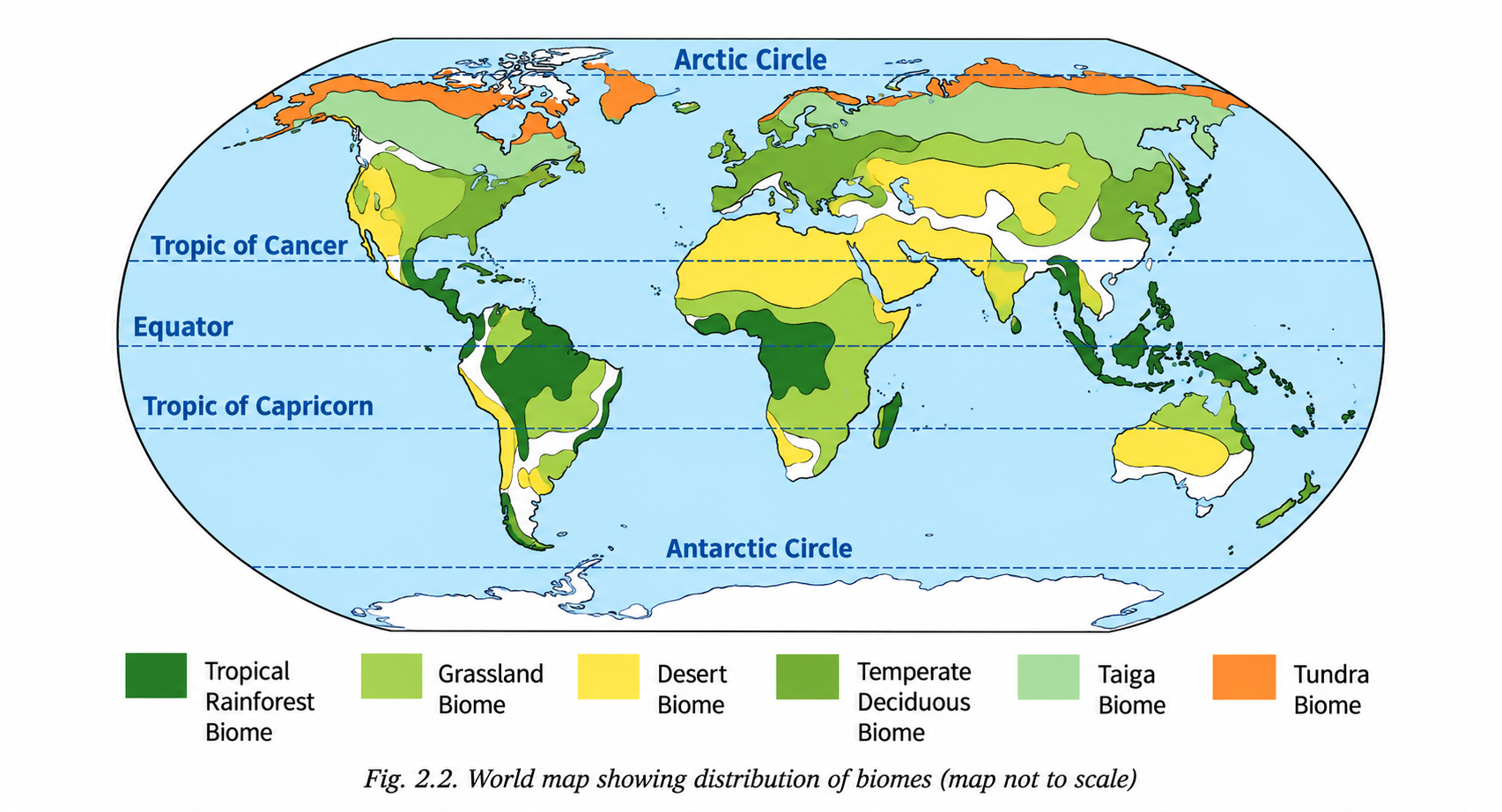
Q1. Which type of biome is found in smaller, separate regions, and why?
Answer:
The Temperate Deciduous Forest Biome and Tropical Rainforest Biome (in specific regions like Central America, Western Ghats, and Southeast Asian islands) are found in smaller, scattered patches across continents.
Reasons:
- Geographical Isolation: Landmass distribution, ocean currents, and coastal positions create isolated micro-climatic zones with specific temperature and rainfall levels.
- Topography: Mountain ranges and changing elevation disrupt uniform climatic belts, creating fragmented biomes.
- Human Interventions: Extensive land clearance for agriculture, urban expansion, and industrialization has fragmented large continuous biomes into smaller, separated pockets.
Q2. Which continent has the least number of biomes? What could be the reason for this?
Answer:
Antarctica has the least number of biomes (dominated almost entirely by an ice sheet / polar desert biome).
Reasons:
- Extreme Geographic Location: Located entirely within the Antarctic Circle around the South Pole, receiving limited solar radiation.
- Extreme Cold Climate: Extremely low temperatures year-round prevent soil formation and the growth of trees or diverse vegetation.
- Permanent Ice Cover: Most of the land is permanently locked under heavy glaciers, limiting life forms mostly to coastal marine ecosystems.
Q3. Why are there areas that do not have any specific biomes?
Answer:
Certain regions—such as high mountain ranges (e.g., the Himalayas, the Andes, the Alps) and permanent ice caps—do not fall under a single specific biome category because:
- Altitude Variations: In high mountain systems, temperature and atmospheric pressure change rapidly with height, causing multiple micro-biomes (from subtropical forests at the base to alpine tundra and ice at the peak) within a short physical distance.
- Extreme Environmental Conditions: Absolute polar ice sheets lack substantial vegetation to establish a traditional terrestrial ecosystem hierarchy.
Let's Explore (Page 24) — Ideal Structure of a Rainforest Biome
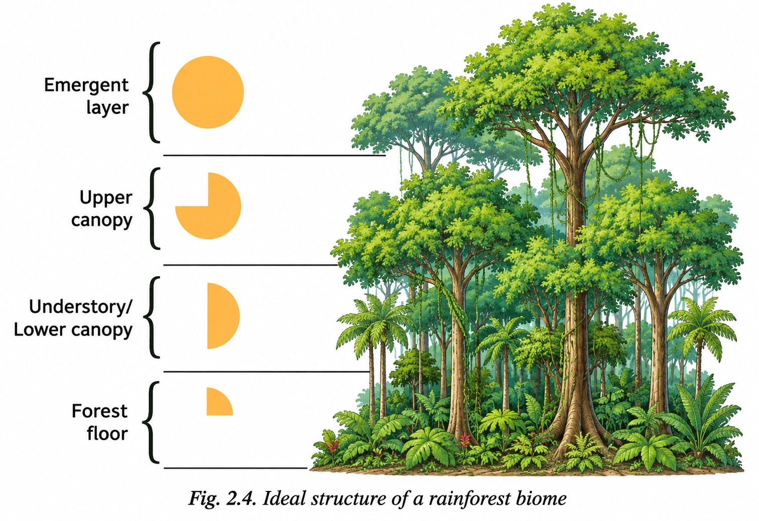
Q1. Look at the layers of vegetation in a rainforest (Fig. 2.4). What do the yellow shapes in the figure indicate?
Answer:
The yellow shapes in the diagram represent the sunlight penetration falling upon the canopy levels. They highlight how sunlight filter strength decreases as it moves downward through the vertical structure:
- Emergent Layer: Receives direct, intense sunlight.
- Upper Canopy: Blocks up to 90–95% of sunlight, creating a dense green shield.
- Understory & Forest Floor: Receive very filtered, faint sunlight, forcing lower plants to adapt to shade conditions.
Let's Explore (Page 25) — Grassland Biome
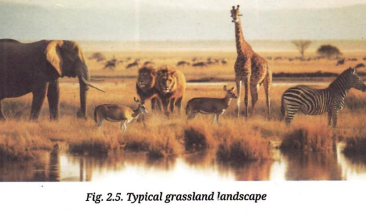
Q1. Observe Fig. 2.5 and explore which of these animals you will find in the grasslands of India.
Answer:
In Indian grasslands (such as the Terai-Duar savanna, Velavadar in Gujarat, and Deccan grassland patches), typical animals found include:
- Grazers & Herbivores: Indian Blackbuck, Chinkara (Indian Gazelle), Indian Rhinoceros (Terai grasslands), Axis Deer (Chital), and Nilgai.
- Predators & Birds: Indian Leopard, Striped Hyena, Indian Wolf, Great Indian Bustard, and Bengal Florican.
Let's Explore (Page 26) — Desert Biome & Camel Adaptations
Q1. What types of activities do you think people in desert regions generally undertake to sustain their households and livelihood?
Answer:
People living in desert regions adapt to water scarcity through specific occupations:
- Nomadic Pastoralism & Livestock Rearing: Herding camels, goats, and sheep for milk, wool, leather, and transport.
- Rainfed Agriculture & Oasis Farming: Cultivating drought-resistant crops like millet (bajra), pulses, and dates near water sources or during monsoon seasons.
- Handicrafts & Cottage Industries: Leatherwork, carpet weaving, block printing, and embroidery.
- Ecotourism & Cultural Tourism: Desert safaris, folk cultural performances, and local heritage hospitality.
Q2. With the help of your teacher, explore how people address issues related to the availability of water in desert areas.
Answer:
Desert communities address water scarcity through traditional and modern infrastructure:
- Traditional Rainwater Harvesting: Constructing Taankas (underground rainwater storage cisterns), Johads (percolation check dams), Bawris (stepwells), and Khadins (embankments to conserve moisture for crops).
- Canal Irrigation Projects: Utilizing canals like the Indira Gandhi Canal in Rajasthan to supply drinking and irrigation water from distant rivers.
- Deep Tube Wells & Water Tankers: Groundwater extraction and community-managed tanker networks.
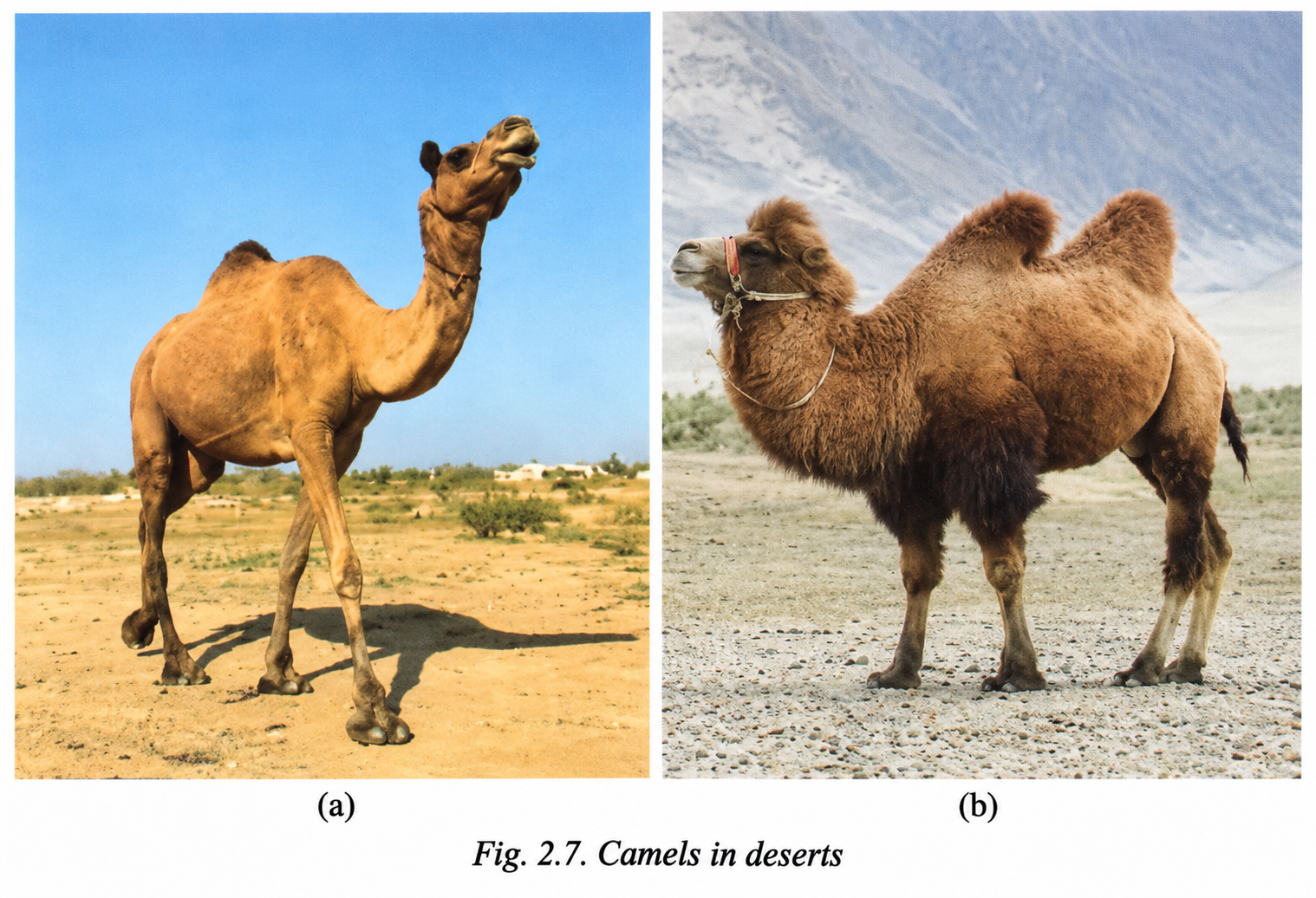
Q3. Compare the physical features of the Rajasthan camel (Fig. 2.7a) and the Nubra Valley (Ladakh) camel (Fig. 2.7b). Considering the climatic conditions, why do you think the Nubra Valley camel might have a different fur density than the Rajasthan camel?
Answer:
The comparative features and physiological adaptations of both camels are detailed below:
| Feature | Rajasthan Camel (Thar Desert) | Nubra Valley Camel (Ladakh) |
|---|---|---|
| Type / Humps | Single hump (Dromedary camel) | Double humps (Bactrian camel) |
| Fur Density & Coat | Thin, short hair coat to dissipate excessive heat quickly. | Thick, dense, shaggy fur coat to insulate against sub-zero winter temperatures. |
| Climatic Environment | Hot, dry desert with high solar radiation and elevated ambient temperatures. | Cold high-altitude desert with freezing winds and sub-zero winter temperatures. |
| Adaptation Reason | Helps body heat escape and prevents sweating in severe heat. | Traps air layers to keep the camel warm during extremely harsh winters in cold mountainous deserts. |
Think About It (Page 27) — Tundra vs. Himalayan Mountain Ecosystem
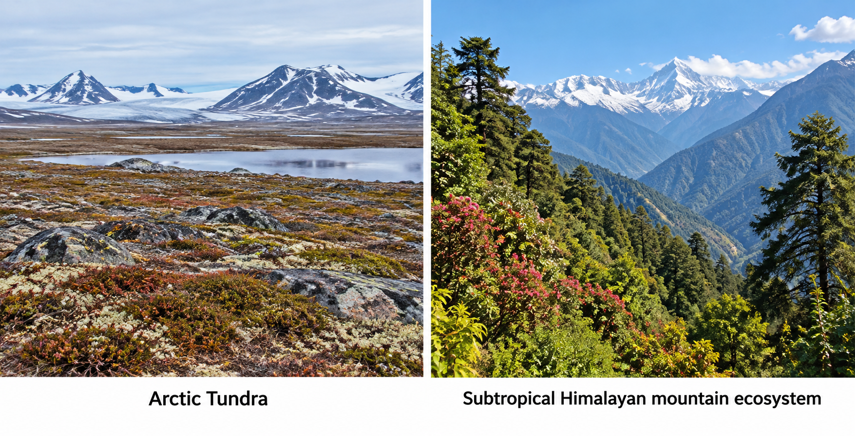
Q1. Tundra in polar regions has mosses, lichens, shrubs, etc., while the Himalaya, in the subtropics, is dominated by conifers. What could be the reason for this? What difference do you find in the animals found in these two regions? Which species are found only in the Himalaya?
Answer:
1. Reason for Vegetation Difference:
- Soil & Permafrost: Polar tundra has permanently frozen subsoil (permafrost) and extremely short growing seasons, preventing deep-rooted tall trees from growing. Vegetation remains restricted to surface lichens, mosses, and dwarf shrubs.
- Sunlight & Latitude: The Himalayas are located in the subtropical zone where intense sunlight during warmer months and unfrozen soil depths allow deep-rooted coniferous trees (like Pine, Deodar, Spruce, and Fir) to grow up to high elevation tree lines.
2. Differences in Wildlife:
- Polar Tundra Fauna: Species adapted to flat ice landscapes and extreme low temperatures (e.g., Polar Bear, Arctic Fox, Reindeer, Musk Ox, Lemmings).
- Himalayan Fauna: Species adapted to steep, rugged mountain slopes and high elevation gradients (e.g., Snow Leopard, Himalayan Yak, Musk Deer, Bharal/Blue Sheep).
3. Species Found Exclusively (Endemic) to the Himalayas:
- Himalayan Monal (bird)
- Himalayan Musk Deer
- Himalayan Tahr
- Himalayan Brown Bear
- Himalayan Blue Sheep (Bharal)
Let's Explore (Page 28) — Community Ecosystem Observation Table
Q1. Explore your local environment (village, city, town, or residential area). Observe how people, plants, and animals build structures and interact. Complete the table with your findings.
Answer:
| Component Type | Examples Observed | Interaction with Humans |
|---|---|---|
| Trees / Vegetation / Plants | Neem, Peepal, Mango trees, Tulsi plants, grass lawns. | Provides shade, fresh oxygen, fruits, shade during summers, and medicinal leaves for households. Human beings water them and prune branches. |
| Insects | Honeybees, Ants, Butterflies, Earthworms, Mosquitoes. | Bees and butterflies pollinate local flowers/gardens; earthworms enrich soil for farming/gardening. Humans take measures to control mosquitoes. |
| Animals | Cows, Stray Dogs, Squirrels, Birds (Pigeons, Sparrows). | Cows provide milk; dogs offer security and companionship; birds are fed seeds/water on roofs by residents. |
| Non-living Things | Soil, Water ponds, Paved roads, Concrete houses, Solar panels. | Humans build roads and houses for shelter, construct drains to manage water, and harvest soil nutrients for home gardening. |
Let's Map (Page 29) — Biome Pyramid & Location Placement
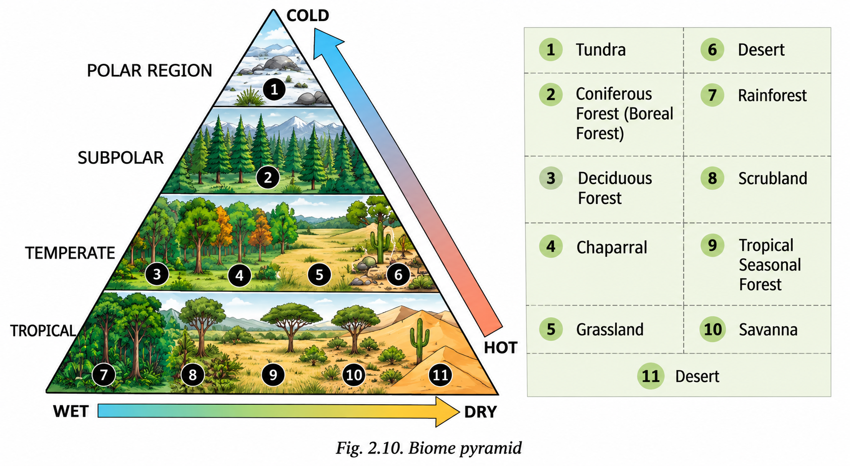
Q1. Mark the following regions at appropriate levels on the Biome Pyramid (Fig. 2.10): Andaman & Nicobar Islands, Keralam, Ladakh, Chhattisgarh, Odisha, Meghalaya, and Lakshadweep. Where will you place your home?
Answer:
| Region | Climatic Position on Biome Pyramid | Biome Category |
|---|---|---|
| Andaman & Nicobar Islands | Hot & Wet zone | Rainforest (Biome 7) |
| Keralam | Hot & Wet zone | Rainforest / Tropical Evergreen (Biome 7) |
| Ladakh | Cold & Dry zone | Tundra / Cold Desert (Biome 1 & 6) |
| Chhattisgarh | Warm & Moderate Moisture zone | Deciduous Forest / Tropical Seasonal Forest (Biome 3 / 9) |
| Odisha | Warm & Wet/Moist zone | Tropical Seasonal Forest / Deciduous Forest (Biome 9 / 3) |
| Meghalaya | Warm/Temperate & Extremely Wet zone | Rainforest / Deciduous Forest (Biome 7 / 3) |
| Lakshadweep | Hot & Wet Island climate | Rainforest / Tropical Scrub (Biome 7) |
| Your Home Location (e.g., Guwahati, Assam) | Warm & Wet zone | Tropical Seasonal Forest / Deciduous Forest (Biome 9) |
Q2. There is no arrow on the third side of the triangle (Fig. 2.10). What would happen if we drew an arrow? Would it point upwards or downwards?
Answer:
The third side of the triangle represents the combined gradient of Energy Availability / Overall Biological Productivity (Biodiversity density and biomass volume).
- If an arrow is drawn along the hypotenuse from the Cold/Dry peak down to the Hot/Wet base, it would point downwards towards the Tropical Rainforest base.
- Reason: Biological productivity, biomass density, species richness, and thermal energy increase steadily as you move from freezing dry polar deserts (Tundra) toward warm, moisture-rich equatorial zones (Rainforests).
Let's Map (Page 31) — Map Identification of Indian Biodiversity Hotspots
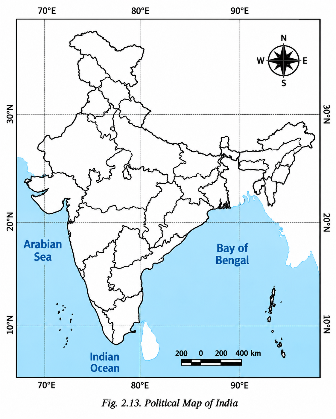
Q1. Mark and name the following regions on the map in Fig. 2.13. Gather information about these biodiversity regions and discuss their features:
- Namdapha National Park
- Rann of Kutch
- Gahirmatha Beach
- Gulf of Mannar
- Pachmarhi
- Achanakmar-Amarkantak
Answer:
| No. | Biodiversity Region | State / UT Location | Key Geographical & Ecological Features |
|---|---|---|---|
| 1 | Namdapha National Park | Arunachal Pradesh | Famous for subtropical biodiversity, dense forest canopies, and being home to four big cat species (Tiger, Leopard, Snow Leopard, Clouded Leopard). |
| 2 | Rann of Kutch | Gujarat | Vast salt desert ecosystem turning into seasonal marshlands during monsoons; primary breeding ground for Flamingos and Indian Wild Ass (Khur). |
| 3 | Gahirmatha Beach | Odisha | World's largest nesting beach (mass nesting / Arribada) for endangered Olive Ridley Sea Turtles. |
| 4 | Gulf of Mannar | Tamil Nadu | India's premier Marine Biosphere Reserve featuring rich coral reefs, sea grass beds, and endangered Dugongs (Sea Cows). |
| 5 | Pachmarhi | Madhya Pradesh | Biosphere Reserve in the Satpura Range featuring Sal and Teak forests, endemic flora, wild orchids, and deep gorge ecosystems. |
| 6 | Achanakmar-Amarkantak | Chhattisgarh & Madhya Pradesh | Biosphere reserve bridging the Vindhya and Satpura ranges; source region of major rivers like Narmada, Son, and Johilla. |
Let's Explore (Page 32) — Ecotourism & Tourist Code of Conduct
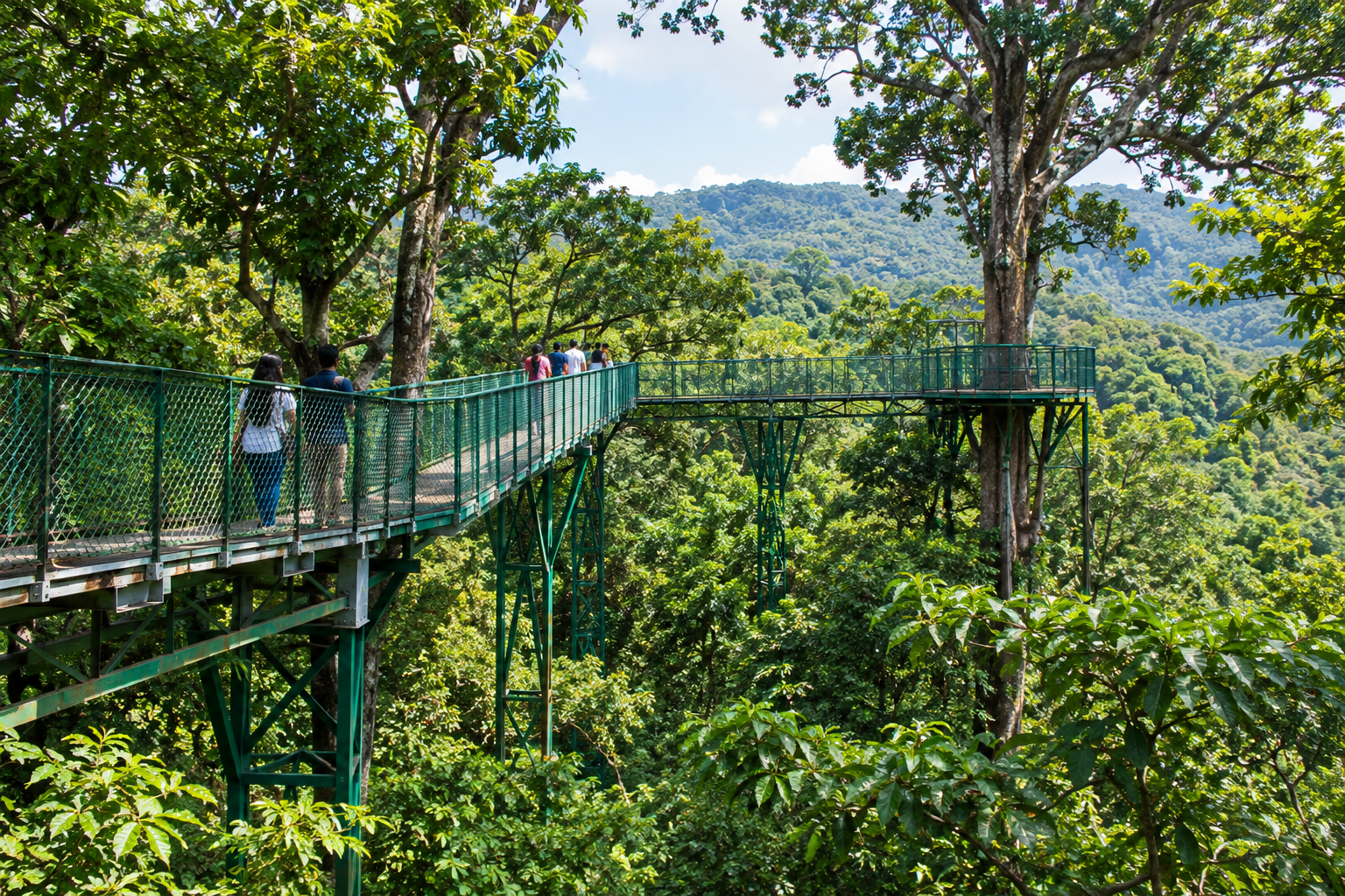
Q1. Is there any ecotourism site in your State/UT? Collect some information and discuss with your friends.
Answer:
Kaziranga Eco-Village & Pobitora Wildlife Sanctuary (Assam):
- Location: Nagaon/Golaghat and Morigaon districts of Assam.
- Features: Promotes community-led Jeep safaris, elephant observation, birdwatching tours, and local ethnic homestays run by indigenous villager cooperatives.
- Impact: Provides sustainable income to local youths as naturalists and village guides while protecting the habitat of the Greater One-Horned Rhinoceros.
Q2. What should be a tourist's behaviour while visiting any tourist site? What should one be mindful of?
Answer:
A responsible tourist should follow the rules outlined below:
- Zero Littering: Carry back all plastic wrappers, bottles, and non-biodegradable waste. Do not pollute water sources or trails.
- Respect Wildlife: Maintain safe distances from animals, avoid making loud noises, do not play music, and never attempt to feed wild animals.
- Cultural Sensitivity: Respect local community traditions, ask permission before taking photos of indigenous people, and dress modestly near sacred groves/sites.
- Support Local Economy: Purchase handcrafted souvenirs directly from local artisans and employ certified local guides.
- Do Not Disturb Nature: Stay strictly on designated trekking tracks; do not pluck rare flowers, carve on trees, or remove forest produce.
Let's Explore (Page 36) — Tribal Market Products & GI Tagging
Q1. Try to identify and classify the items for sale in the images given in Fig. 2.18. Also, make a list of the food and medicinal varieties available in your local market.
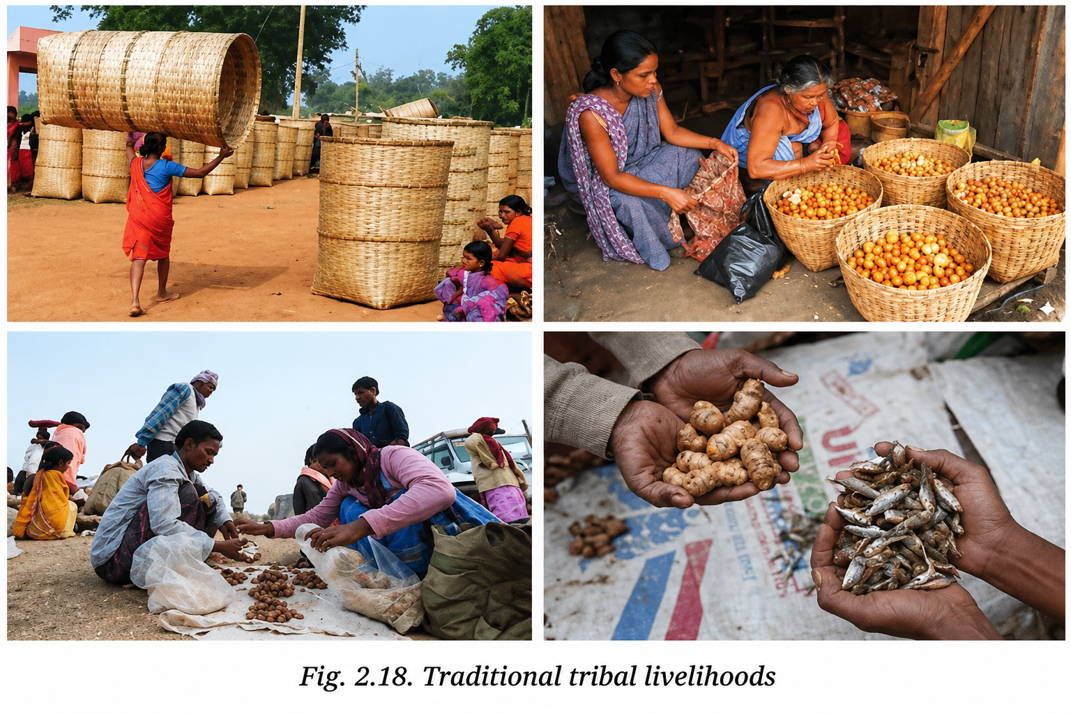
Answer:
1. Classification of Items in Fig. 2.18:
- Handicrafts & Tools: Bamboo baskets, handwoven cane mats, wooden utensils, broomsticks.
- Edible Forest Produce: Wild berries, tubers, mushrooms, organic wild honey, Mahua flowers, dry tendu leaves.
- Medicinal Herbs: Raw roots, tree barks, dried leaves, natural gums and resins.
2. Local Market Varieties:
| Category | Items Available in Local Market |
|---|---|
| Edible Food Varieties | Bamboo shoots, wild leafy greens (such as Brahmi, Dhekia xak), raw honey, amla, jackfruit, lotus stem. |
| Medicinal / Herbal Varieties | Tulsi, Neem barks, Ashwagandha roots, Giloy stems, Turmeric (Haldi), Aloe vera, Triphala powders. |
Q2. Can you explain how GI tagging of forest products connects geography, cultural traditions, local governance, and rural economy?
Answer:
| Dimension | How GI Tagging Connects It |
|---|---|
| Geography | Links product uniqueness directly to specific soil, microclimate, altitude, and forest ecology (e.g., forest-influenced soils of Tezpur for Litchi or Western Ghats climate for Nilgiri Tea). |
| Cultural Traditions | Protects age-old indigenous gathering techniques, sustainable processing knowledge, and community heritage passed down through generations (e.g., tribal harvesting of Kandhamal Haldi). |
| Local Governance | Empowers Gram Sabhas, tribal cooperatives, and self-help groups to register ownership, prevent counterfeit copies, and regulate legal harvesting rights. |
| Rural Economy | Ensures higher market prices, direct trade access, and fraud protection, boosting income and self-reliance for forest-dwelling producers. |
Q3. Can you name some GI-tagged forest products from your state or union territory?
Answer:
- Assam: Tezpur Litchi, Kaji Nemu (Assam Lemon), Karbi Anglong Ginger.
- Jammu & Kashmir: Ramban Sulai Honey, Kashmir Saffron.
- Odisha: Kandhamal Haldi (Turmeric).
- Karnataka: Channapatna Toys (made from Aale mara tree wood).
- Meghalaya: Khasi Mandarin.
Think About It & Let's Explore (Page 39) — PMUY Scheme & Human-Wildlife Interaction
Q1. You may have heard about the Pradhan Mantri Ujjwala Yojana (PMUY). How are the benefits of this scheme impacting the health of women?
Answer:
The Pradhan Mantri Ujjwala Yojana (PMUY) provides free LPG gas connections to rural and BPL households, benefiting women in several key ways:
- Reduces Indoor Air Pollution: Replacing traditional firewood, cow dung cakes, and crop residue stoves prevents exposure to harmful smoke containing fine particulate matter (PM2.5) and carbon monoxide.
- Health Protection: Lowers the incidence of chronic respiratory illnesses, eye infections, asthma, and heart conditions among rural women.
- Reduces Physical Hardship: Saves rural women hours of intense physical labor spent trekking into forests to collect heavy firewood bundles.
- Minimizes Safety Risks: Reduces risks of wild animal attacks, insect bites, and physical injuries associated with foraging in isolated forests.
Q2. Which wild animals (like monkeys or deer) have you seen in your residential area? Identify the causes behind these animals' presence in human settlements.
Answer:
Animals Observed: Rhesus Macaque monkeys, Stray Langurs, Wild Boars, Peacocks, and Spotted Deer near fringe urban zones.
Causes for Presence in Human Settlements:
- Habitat Destruction & Fragmentation: Deforestation, road construction, and urban expansion push into natural wildlife corridors and reduce forest core areas.
- Food Scarcity in Natural Habitats: Depletion of native wild fruit trees forces opportunistic animals into residential areas in search of food.
- Easy Availability of Garbage/Food Waste: Open dustbins, leftover food dumping, and roadside garbage offer easily accessible meals.
- Drying of Natural Water Bodies: Seasonal drying of forest streams forces animals into towns to search for water.
Let's Explore (Page 42) — Satellite View of Ecological Commons (Water Tanks)
Q1. Observe Fig. 2.24 from the School Bhuvan-NCERT Geoportal carefully and see if you can identify some of the tanks and mark the agricultural fields irrigated by them.
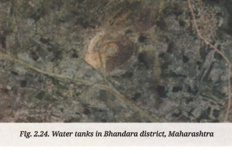
Answer:
In satellite geoportal imagery (such as Fig. 2.24 depicting Bhandara district, Maharashtra):
- Identifying Water Tanks: Represented as dark blue or greenish-black irregular impoundments bound by raised earthen embankments (bunds) on three sides.
- Identifying Irrigated Fields: Shown as bright green or dark-patterned rectangular agricultural plots located lower downhill from the tank bunds.
- Irrigation Mechanism: Gravity-fed small open channels (pynes/canals) run out from the embankment base directly into surrounding fields, demonstrating traditional community-led water storage.
Questions and Activities (End-of-Chapter Exercises - Page 43)
1. Why does India have diverse biomes? How does the local geography connect to the diversity?
Answer:
India possesses remarkable biome diversity—ranging from tropical rainforests and dry deserts to alpine tundras and coastal mangroves—due to the following geographical factors:
- Vast Latitudinal & Longitudinal Extent: Extending from 8°4' N to 37°6' N, India spans tropical, subtropical, and temperate climatic belts.
- Varied Topography & Relief: High mountain barriers (the Himalayas), elevated plateaus (the Deccan), flat fertile plains (Indo-Gangetic), and long coastal corridors create distinct elevation and temperature gradients.
- Monsoonal Rainfall Variations: Rainfall varies dramatically across regions—from over 1,000 cm annually in Meghalaya (Sohra/Mawsynram) to under 15 cm in the Thar Desert and Ladakh cold desert.
- Altitudinal Zonation: Elevation changes in mountain ranges like the Himalayas compress climatic conditions—moving from tropical foothills up to alpine tundra zones over short distances.
2. Make a list of economically valuable native plants in your region and comment on their abundance.
Answer:
| Native Plant Name | Economic / Traditional Utility | Current Abundance Status |
|---|---|---|
| Bamboo (Bambusoideae) | Construction, paper pulp, handicrafts, cottage industries, and edible shoots. | Abundant: Widely available across forests, homestead gardens, and river valleys. |
| Teak (Tectona grandis) & Sal | High-grade durable timber for furniture, housing structures, and railway sleepers. | Moderate to Depleted: Restricted mostly to reserved forest zones and protected parks due to past logging. |
| Amla (Indian Gooseberry) | Rich source of Vitamin C, used in Ayurvedic medicines, cosmetics, and food products. | Fairly Common: Grown in household backyards and natural deciduous forest slopes. |
| Neem (Azadirachta indica) | Natural pesticide, antibacterial agent, organic fertilizer, and soaps. | Abundant: Common across plains, roadside avenues, and residential zones. |
| Agarwood (Aquilaria malaccensis) | High-value aromatic resin used in perfumes and essential oils. | Rare / Critically Threatened in Wild: Cultivated selectively in commercial plantations. |
3. Prepare a map of your state or Union Territory showing national parks and sanctuaries.
Answer:
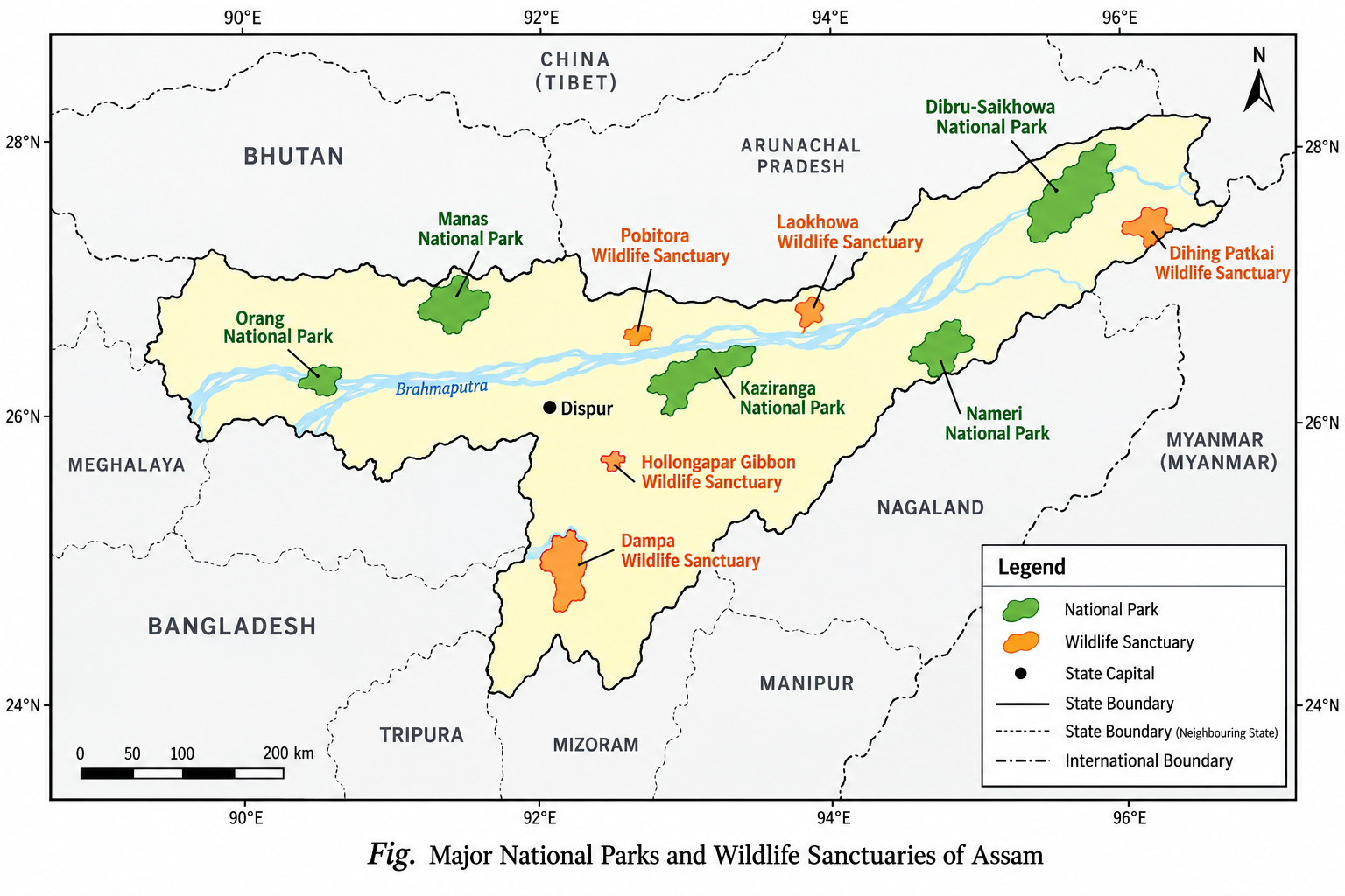
Guidelines for Map Preparation (e.g., Assam State):
- National Parks to Mark: Kaziranga National Park, Manas National Park, Dibru-Saikhowa, Nameri, Orang, Raimona, and Dihing Patkai National Park.
- Wildlife Sanctuaries to Mark: Pobitora Wildlife Sanctuary, Gibbon Wildlife Sanctuary, Deepor Beel (Ramsar Wetland Site).
- Legend Key: Use green tree symbols for National Parks and red shaded patches for Wildlife Sanctuaries.
4. Study the impact of forest fires on people dependent on forests. Try to include the causes, losses, and preventive measures.
Answer:
Forest fires affect communities that rely on forest resources for their daily survival. The major causes, losses, and prevention methods are outlined below:
| Aspect | Detailed Points & Impact Analysis |
|---|---|
| Causes |
|
| Losses / Impacts |
|
| Preventive Measures |
|
5. Why are forests often called the 'lungs of the Earth'?
Answer:
Forests are called the 'lungs of the Earth' because of their role in sustaining global life processes:
- Oxygen Generation: Through photosynthesis, green plants absorb carbon dioxide (CO2) and release huge volumes of oxygen (O2) into the atmosphere, which is essential for aerobic life.
- Carbon Sequestration: Dense forests (especially tropical rainforests like the Amazon and Asian equatorial belts) absorb millions of tonnes of atmospheric carbon dioxide, acting as major carbon sinks that regulate global warming.
- Air Filtration: Trees trap suspended dust particles, filter airborne pollutants, and maintain the chemical balance of gases in the atmosphere.
6. If large forest areas continue to be destroyed, what do you think would be its long-term effect on the global climate?
Answer:
Continuous large-scale deforestation would lead to severe long-term global climate consequences:
- Accelerated Global Warming: Burning and felling trees releases stored carbon into the atmosphere as carbon dioxide (CO2), worsening the greenhouse effect.
- Disruption of Rainfall Patterns: Deforestation reduces transpiration, disrupting moisture cycles, weakening monsoons, and causing severe regional droughts.
- Extreme Weather Events: Increased frequency of heatwaves, intense dry spells, unpredictable storms, and flash floods due to altered global atmospheric circulation.
- Loss of Biodiversity & Soil Degradation: Soil erosion increases, converting fertile lands into degraded deserts (desertification) and accelerating mass extinction of species.
- Melting of Polar Glaciers & Sea Level Rise: Elevated atmospheric temperatures accelerate polar ice melting, leading to coastal inundation.
7. Discuss some traditional forest conservation methods with your grandparents or an elderly person.
Answer:
Key traditional forest conservation practices passed down through generations include:
- Protection of Sacred Groves: Small forest patches (known as Devrai in Maharashtra, Devarakadu in Karnataka, Kavu in Kerala, and Sarna in Jharkhand) are protected through cultural traditions. Felling trees or hunting within these groves is taboo, preserving rare flora and fauna.
- Selective & Rotational Harvesting: Indigenous tribes collect only fallen twigs, mature herbs, and dry branches, ensuring parent plants are left intact to regenerate naturally.
- Worship of Sacred Trees: Reverence for specific tree species—such as Peepal, Banyan, Neem, and Khejri—prevents them from being cut down. Historical movements like the Bishnoi Movement in Rajasthan demonstrate this deep commitment to tree protection.
- Community Rituals: Performing traditional ceremonies to seek blessings from forest deities before gathering seasonal produce helps prevent over-exploitation.
8. How do forest dwellers contribute to the protection and conservation of forests?
Answer:
Forest dwellers act as effective natural guardians of forest ecosystems through several roles:
- Traditional Knowledge Bearers: Possess deep understanding of local biodiversity, plant breeding cycles, and medicinal herbs, helping harvest resources without causing harm.
- First Line of Defense Against Illegal Logging & Poaching: Forest communities alert authorities about timber theft, illegal wildlife poaching, and unauthorized encroachments.
- Active Fire Prevention: Help clear dry leaves, create traditional firebreaks, and suppress early ground fires before they can spread.
- Grassroots Movements: Historical leadership in environmental conservation movements—such as the Bishnoi Movement and the Chipko Movement (where women hugged trees to block logging).
- Community Forest Governance: Participating in self-governance models like the Mendha Lekha village initiative under the Forest Rights Act (2006) to regulate resource extraction, ban commercial clear-cutting, and manage forest commons sustainably.
9. What is a forest fire? Prepare a plan for prevention and mitigation of forest fires.
Answer:
Definition: A forest fire is an uncontrolled fire occurring in wild vegetation, dry brush, or forest lands that spreads rapidly due to dry winds, high temperatures, and abundant combustible dry biomass.
Comprehensive Prevention and Mitigation Action Plan
- Phase 1: Preventive Measures (Before Fire Season)
- Create and clear wide fire-lines (cleared vegetation strips) throughout dry forest blocks before summer begins.
- Conduct controlled burns under forest department supervision to eliminate dry leaf buildup.
- Enforce strict bans on smoking, open campfires, or burning crop stubble near forest borders.
- Phase 2: Early Warning & Monitoring (During Fire Season)
- Use satellite remote sensing platforms (like the School Bhuvan-NCERT Geoportal and Forest Survey of India alert systems) for real-time fire hotspot tracking.
- Erect watchtowers equipped with wireless communications in sensitive, fire-prone zones.
- Phase 3: Mitigation & Firefighting (Active Response)
- Form specialized rapid-response local fire control teams equipped with beaters, portable water pumps, and flame-retardant gear.
- Mobilize local Joint Forest Management (JFM) village volunteers to suppress ground fires early.
- Phase 4: Post-Fire Restoration & Recovery
- Replant native, drought-resistant indigenous tree species across burnt forest zones.
- Construct soil check-dams along burned slopes to prevent severe erosion during the monsoon.