
NCERT Solutions – Chapter 1: Oceans and Life
This page offers step-by-step NCERT solutions for Chapter 1, Oceans and Life, from the Grade 9 Social Science textbook Understanding Society: India and Beyond. The chapter explores ocean relief, the movement of ocean water through waves, tides and currents, maritime zones, early warning systems for cyclones and tsunamis, and the sustainable use of marine resources. All questions and exercises are solved with clear explanations to help students understand the vital connection between oceans and human life.
The Big Questions
Q1. What is the importance of ocean relief?
Answer:
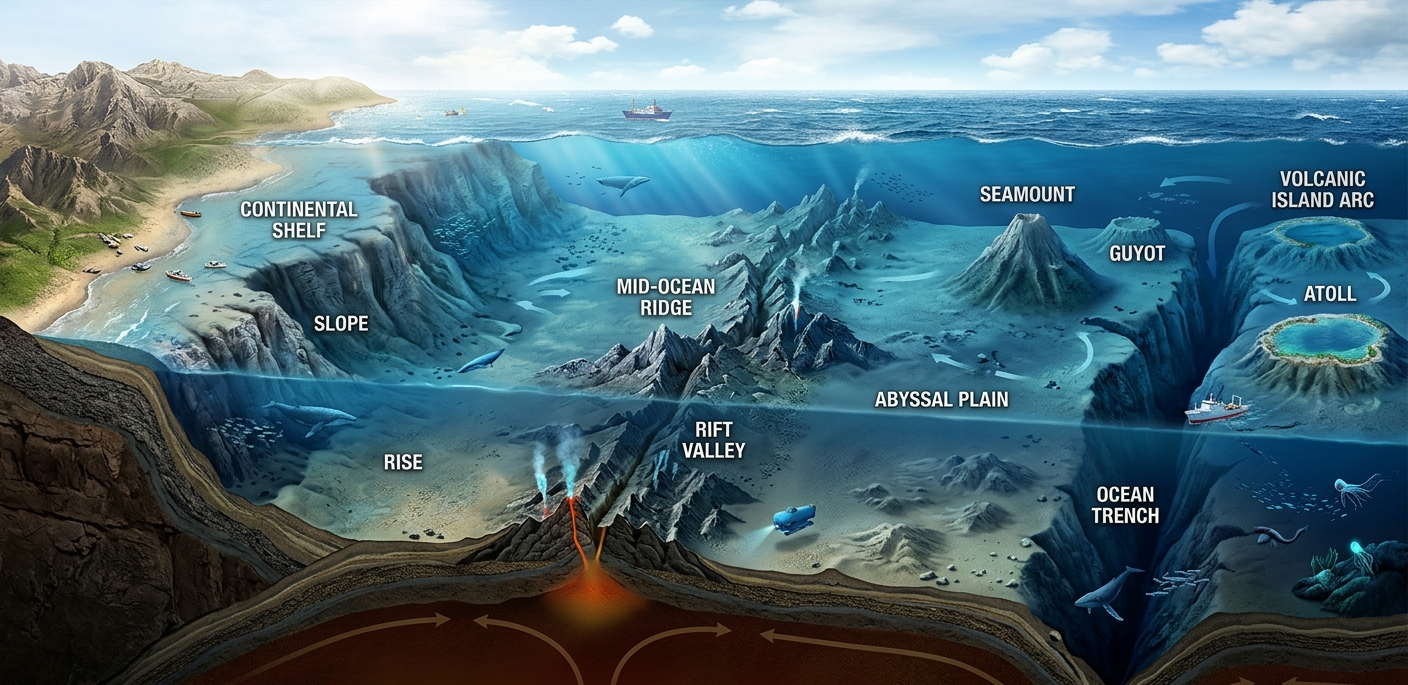
Ocean relief refers to the landforms on the ocean floor, such as continental shelves, slopes, abyssal plains, trenches, mid-oceanic ridges, and seamounts. It is important because:
- Rich resources: Continental shelves are rich in marine life, oil, and natural gas.
- Navigation and safety: Knowledge of underwater features helps ships navigate safely and avoid hazards.
- Marine life: Relief features influence the distribution of nutrients and marine organisms.
- Ocean movements: Features like ridges and trenches affect the flow of currents and mixing of water.
- Scientific study: Understanding ocean relief helps in studying earthquakes, tsunamis, and volcanic activity.
Q2. How does ocean water movement impact life and environment?
Answer:
Ocean water moves through waves, tides, and currents, and each type of movement has significant effects:
- Waves: Shape coastlines through erosion and deposition, create landforms like sea caves and beaches, and carry energy across oceans.
- Tides: Help in navigation, fishing, and generation of tidal energy; they also influence coastal ecosystems.
- Currents: Regulate climate by transporting warm and cold water; the meeting of warm and cold currents creates nutrient-rich fishing grounds.
- Marine life: Movement of water distributes nutrients and oxygen, supporting diverse marine organisms.
- Environment: Ocean movements influence weather patterns and help maintain the Earth's heat balance.
Q3. Why are maritime zones important for a country?
Answer:
Maritime zones are areas of the sea over which a coastal country has certain rights and responsibilities, as defined by international law (UNCLOS). They are important because:
- Economic rights: They give the country exclusive rights to explore and use marine resources such as fish, oil, and minerals.
- Security: They help the country monitor and protect its coast from external threats.
- Trade and navigation: They ensure safe passage for ships and support maritime trade.
- Environmental protection: They allow the country to regulate activities to prevent pollution and protect marine ecosystems.
- International recognition: They define the country's legal boundaries at sea, reducing conflicts with neighbouring nations.
Q4. How can we use ocean resources in a sustainable way?
Answer:
Sustainable use of ocean resources means using them in a way that meets present needs without harming marine ecosystems for future generations. This can be done by:
- Responsible fishing: Avoiding overfishing, using selective gear, and respecting breeding seasons.
- Reducing pollution: Preventing plastic, chemical, and oil pollution from entering the oceans.
- Renewable energy: Promoting tidal, wave, and offshore wind energy instead of relying only on fossil fuels.
- Marine protected areas: Establishing sanctuaries where human activity is limited to allow ecosystems to recover.
- International cooperation: Following laws like UNCLOS and working together to manage shared ocean resources.
- Awareness and education: Teaching communities about the importance of oceans and how to protect them.
Q5. How do early warning systems help protect people from tsunamis and cyclones?
Answer:
Early warning systems (EWS) are designed to detect, monitor, and alert people about impending ocean hazards. They help protect people in the following ways:
- Detection: Seismic sensors, ocean bottom pressure recorders (OBPRs), and satellites detect undersea earthquakes and changes in sea level.
- Tracking and confirmation: Tide gauges and radars monitor the movement of tsunami waves and confirm the threat.
- Modelling and simulation: Computer models predict the path and intensity of cyclones and tsunamis.
- Warning dissemination: Alerts are sent via satellites, SMS, emails, coastal display boards, and mobile apps to government agencies and the public.
- Evacuation and response: Timely warnings allow people to evacuate to safer places and emergency teams to prepare.
- Public awareness: Training programmes help communities understand warnings and respond appropriately.
India's tsunami early warning system, managed by ITEWC, and cyclone warning services are examples of such systems that have significantly reduced loss of life.
Let's Explore
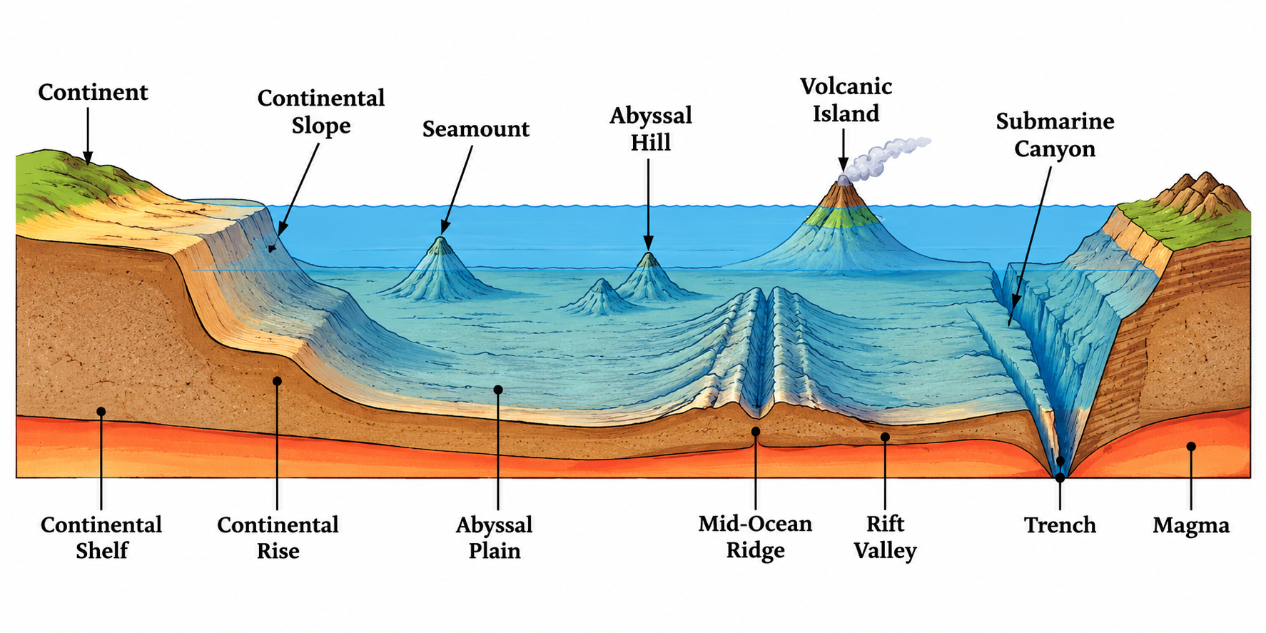
Q1. Looking at Fig. 1.2:
- How do you think these oceanic features would have been formed?
- Which part of the ocean floor appears deep and shallow?
- How do you think these underwater features would have effect on marine life and ocean movements?
Answer:
Formation: Oceanic features are formed by tectonic plate movements, volcanic activity, erosion, and deposition over millions of years. Mid-ocean ridges form where plates diverge and magma rises. Trenches form where plates converge and one plate subducts beneath another. Seamounts are volcanic mountains, and guyots are eroded seamounts.
Deep and shallow parts: The continental shelf is the shallowest part (0–200 m deep), while ocean trenches are the deepest parts (some over 10,000 m deep). Abyssal plains are vast, flat, and deep ocean floors.
Effect on marine life and ocean movements: Shallow continental shelves receive sunlight and nutrients, supporting rich marine life. Trenches and ridges influence the flow of ocean currents. Seamounts can deflect currents and create upwelling zones that bring nutrients to the surface, attracting fish and other marine organisms.
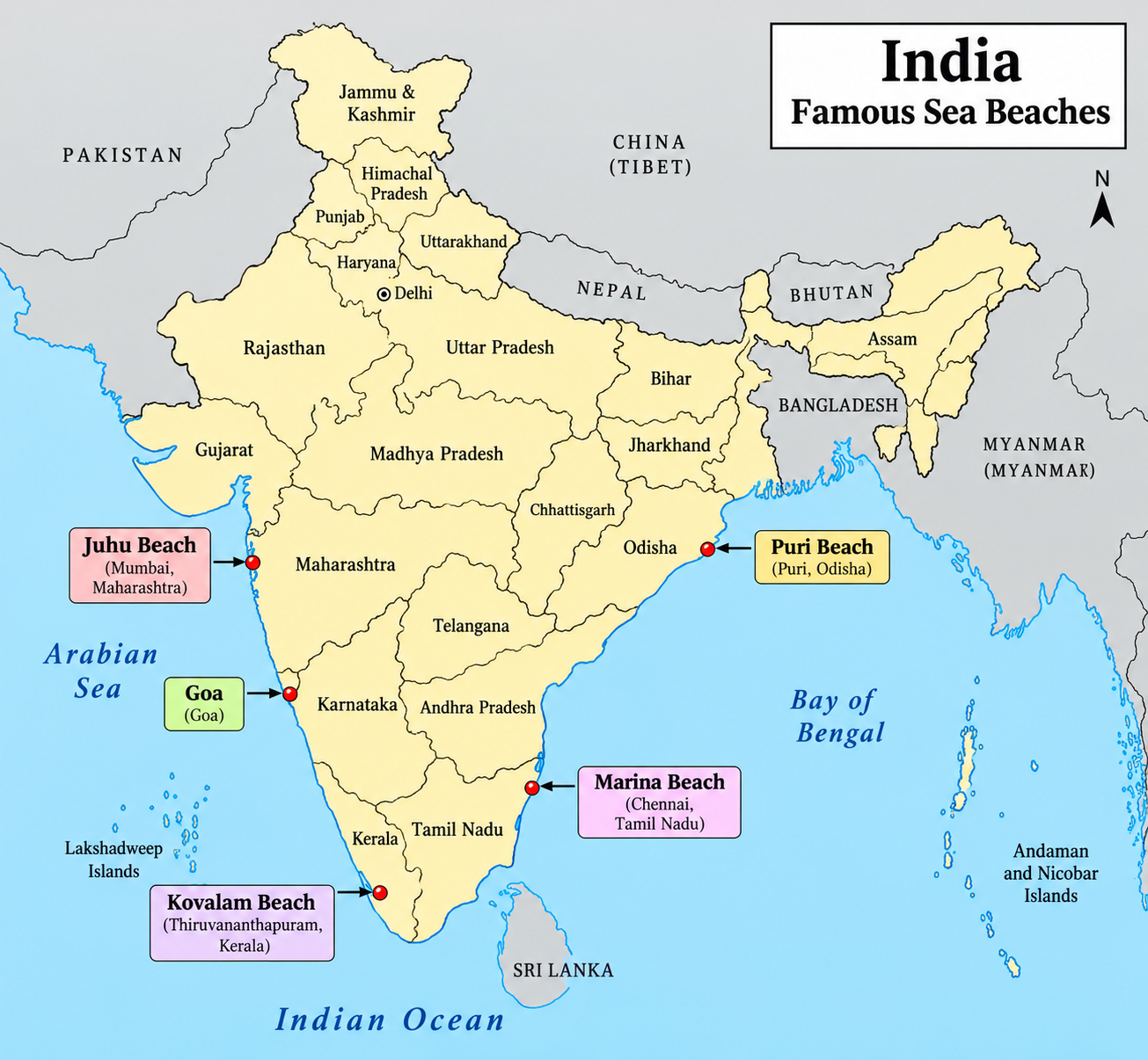
Q2. Find out the names of some famous sea beaches in our country and locate them on the map of India.
Answer:
Some famous sea beaches in India are:
| Beach | State/UT |
|---|---|
| Marina Beach | Tamil Nadu |
| Juhu Beach | Maharashtra |
| Calangute Beach | Goa |
| Puri Beach | Odisha |
| Kovalam Beach | Kerala |
| Radhanagar Beach | Andaman & Nicobar Islands |
Students can locate these beaches on an outline map of India.
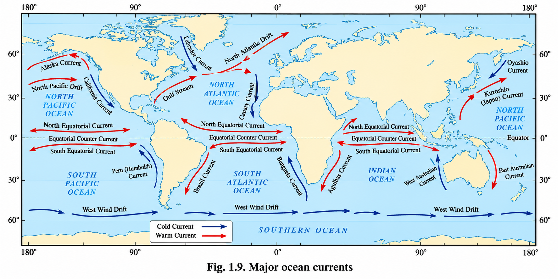
Q3. Observe Fig. 1.9 and take a note on ocean currents along the coastline of India. What is the nature of ocean currents?
Answer:
Along the coastline of India, the ocean currents in the Indian Ocean are influenced by the monsoon winds and reverse direction seasonally:
- Winter (northeast monsoon): Currents flow in a clockwise direction in the Bay of Bengal and Arabian Sea.
- Summer (southwest monsoon): Currents flow in an anticlockwise direction.
The nature of these currents is that they are warm currents, as they flow from warmer tropical regions. The seasonal reversal of currents in the Indian Ocean is unique compared to other oceans.
Q4. Most deaths during the 2004 Indian Ocean tsunami occurred in Indonesia. However, the Island of Simeulue was largely spared from the disaster. Researchers suggest that this was partly because of local folklore, passed down through generations, that helped residents recognise the warning signs of a tsunami and respond quickly. Talk to your elders and find out whether similar folk traditions or stories related to natural disasters exist in your culture. Share these with your classmates and discuss how traditional knowledge can help communities stay safe.
Answer:
This is an open-ended activity. Students should talk to their elders and community members to learn about local stories, songs, or sayings related to natural disasters such as floods, cyclones, earthquakes, or tsunamis.
Guiding points for discussion:
- Traditional knowledge often includes early warning signs, such as unusual animal behaviour, sudden receding of the sea, or changes in wind patterns.
- Communities that preserve and pass on this knowledge can respond faster to disasters.
- Combining traditional knowledge with modern early warning systems can save more lives.
- Students can share examples from their own regions and discuss how this knowledge can be documented and used in disaster preparedness.
Q5. What is the GEMINI device and how does it help fishermen?
Answer:
The GAGAN-Enabled Mariner's Instrument for Navigation and Information (GEMINI) is a handheld device designed for fishermen to ensure their safety at sea.
How it works:
- The GEMINI device receives data from the GAGAN satellite.
- It transfers this data to fishermen's mobile phones through Bluetooth.
- The INCOIS mobile application decodes and displays the information in nine regional languages.
- At present, the communication channel can transmit information up to 50 nautical miles into the sea.
- An upgraded version is expected to provide two-way communication and benefit fishermen travelling up to 300 nautical miles.
Information provided: Alerts about high waves and strong winds, cyclone and tsunami warnings, potential fishing zone advisories, current speeds, bathymetry data, mapping, and risk management information.
Under the Pradhan Mantri Matsya Sampada Yojana (PMMSY), the government provides financial support for GEMINI devices to improve the safety of coastal communities.
Think About It
Q1. Observe the map carefully and note the movement patterns of cold and warm currents. Do you think these currents affect the temperature of nearby coastal regions?
Answer:
Yes, ocean currents significantly affect the temperature of nearby coastal regions:
- Warm currents: They raise the temperature of coastal areas. For example, the Gulf Stream keeps the waters near Norway warm, preventing sea ice from forming easily despite its high latitude.
- Cold currents: They lower the temperature of coastal areas. For example, the Labrador Current carries freezing water along the east coast of Canada, supporting the formation of sea ice and icebergs even at lower latitudes.
Thus, warm and cold currents play a major role in moderating the climate of coastal regions.
Q2. If you receive a tsunami or cyclone alert on your phone right now, do you know the five steps your family should take to stay safe?
Answer:
This is an open-ended question, but here are five general safety steps that families should take upon receiving a tsunami or cyclone alert:
- Stay calm and listen: Pay attention to the alert and follow official instructions.
- Move to higher ground: If you are near the coast, immediately move inland or to a higher elevation.
- Avoid the beach: Do not go to the shore to watch the waves; stay away from the coast.
- Prepare an emergency kit: Keep essential items like water, food, medicines, flashlight, and important documents ready.
- Stay connected: Keep your phone charged and follow updates from official sources. Inform family members of your location and follow evacuation routes.
Students should discuss with their families and create a disaster preparedness plan.
Don't Miss Out
Q1. What is the significance of the Bhadkeshwar Mahadev Temple in Dwarka?
Answer:
The Bhadkeshwar Mahadev Temple in Dwarka, Gujarat, is situated on a small hillock in the Arabian Sea. It is significant because visitors can reach the temple only during low tide, as the stone pathway leading to it is completely submerged during high tide. This demonstrates the powerful influence of tides on human activities and coastal access.
Q2. What was the impact of the 2004 Indian Ocean Tsunami on India?
Answer:
On 26 December 2004, the Indian Ocean Tsunami caused unprecedented devastation across many countries bordering the Indian Ocean. It claimed around 2,30,000 lives and caused severe environmental damage. India was among the worst-affected countries. Tamil Nadu, Puducherry, Andhra Pradesh, Kerala, and the Andaman & Nicobar Islands suffered extensive damage as massive waves swept away people and structures along the coasts. The scale of the disaster led India to establish effective tsunami early warning systems and stronger disaster-management mechanisms, including the Indian Tsunami Early Warning Centre (ITEWC) with a real-time network of tsunami detection buoys.
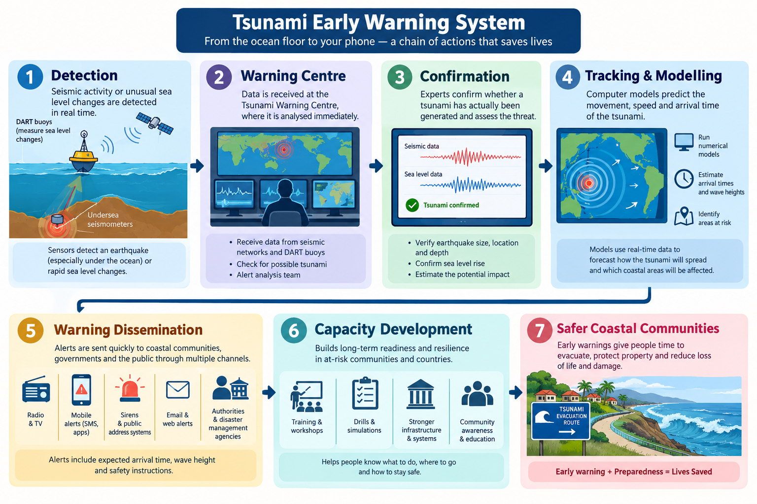
Q3. What are the different elements of the tsunami early warning system?
Answer:
The tsunami early warning system consists of several interconnected elements:
- Detection: A network of seismic stations detects undersea earthquakes in real time.
- Confirmation: Ocean Bottom Pressure Recorders (OBPRs) placed on the seafloor detect the passage of tsunami waves.
- Tracking: Coastal tide gauges and radars monitor changes in sea level to track the arrival and movement of tsunami waves.
- Modelling/Simulation: Computer models simulate the tsunami's path and estimate the time of arrival and areas likely to be affected.
- Warning Centre: The warning centre analyses data and issues alerts.
- Warning Dissemination: Alerts are transmitted via satellite to government agencies and directly to officials and the public through SMS and other communication channels.
- Capacity Development: Training and awareness programmes for officials and coastal communities.
Other components include communication satellites, GPS satellites, seismometer stations, and tide gauge stations.
Marine Resources and Their Significance
Q1. What are marine resources? Classify them with examples.
Answer:
Marine resources are the materials and features found in oceans that have intrinsic or economic value. They are broadly classified into two categories:
| Category | Examples |
|---|---|
| Marine Living Resources | Fish (coastal/neritic and oceanic), bioactive natural products, marine organisms, submerged aquatic vegetation (SAV), non-conventional biofuels |
| Marine Non-living Resources | Minerals: Sand, gravel, deep-sea minerals, gas hydrates Energy: Conventional (oil, natural gas), offshore wind, ocean energy (tidal, wave, current, OTEC) |
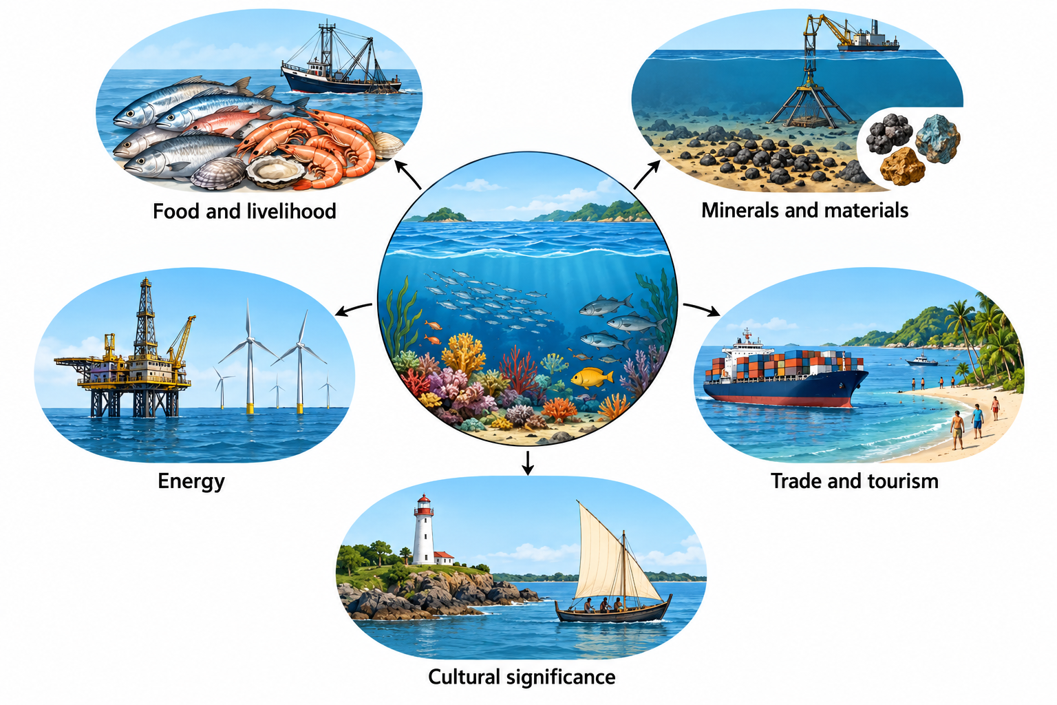
Q2. Why are marine resources significant? Explain with reference to food, livelihood, energy, trade, and culture.
Answer:
Marine resources are vital for humanity and for coastal nations like India:
- Food and Livelihood: Fish are a major source of protein, and fishing and aquaculture support important industries and livelihoods for millions of people.
- Minerals and Materials: Sand, gravel, and deep-sea minerals are used in construction and industry.
- Energy: Offshore oil and gas reserves provide conventional energy, while there is immense potential for renewable 'blue energy' from tides and waves.
- Trade and Tourism: About 90% of global trade by volume is carried by sea, and coastal tourism is a multi-billion dollar industry.
- Cultural Significance: The sacred shaṅkha (conch) and kapardikā (cowrie shells), once used as currency, are regarded as divine treasures from the mythological Samudra Manthana, reflecting the close connection among the sea, prosperity, and culture.
However, marine resources must be used responsibly without disturbing marine ecosystems to ensure they remain available for future generations.
Exercises
Q1. Explain the formation of spring tides and neap tides with the help of a diagram.
Answer:
Spring Tides: Spring tides occur when the Sun, Earth, and Moon are aligned in a straight line. This happens on full moon and new moon days. The combined gravitational pull of the Sun and the Moon causes high tides of unusual heights and low tides that are unusually lower. The water bulges on opposite sides of the Earth due to this strong gravitational pull, leading to the formation of spring tides.
Neap Tides: When the Moon is in its first- and third-quarter phases, the gravitational pull of the Sun and the Moon acts in different directions (at right angles). As a result, the difference between high tide and low tide becomes smaller, producing neap tides.
The diagram should show:
- Spring tide (full moon): Sun, Earth, and Moon in a straight line.
- Spring tide (new moon): Sun, Earth, and Moon in a straight line.
- Neap tide (first-quarter moon): Sun and Moon at right angles relative to Earth.
- Neap tide (third-quarter moon): Sun and Moon at right angles relative to Earth.
Q2. Match the following:
| Column A | Column B |
|---|---|
| A. Continental Shelf | 1. Deepest part of the ocean |
| B. Abyssal Plain | 2. Submerged shallow edge of a continent |
| C. Ocean Trench | 3. Underwater mountain range |
| D. Mid-Ocean Ridge | 4. Vast, flat, and deep ocean floor |
Answer:
The correct matches are:
| Column A | Correct Match |
|---|---|
| A. Continental Shelf | 2. Submerged shallow edge of a continent |
| B. Abyssal Plain | 4. Vast, flat, and deep ocean floor |
| C. Ocean Trench | 1. Deepest part of the ocean |
| D. Mid-Ocean Ridge | 3. Underwater mountain range |
Q3. What are the advantages of high tides?
Answer:
High tides have several advantages:
- Navigation: High tides raise the water level near the shore, allowing ships to enter harbours more easily, especially large vessels like VLCCs.
- Fishing: During high tide, many fish move closer to the shore in search of food and shelter, enabling fishing communities to obtain a better catch.
- Tidal energy: The rise and fall of tidal water can be used to generate electricity in suitable locations.
- Ecosystems: Tides help in the mixing of nutrients and support coastal ecosystems such as mangroves and estuaries.
- Cleaning: Tidal currents help flush out pollutants and keep coastal waters clean.
Q4. Distinguish between warm and cold ocean currents.
Answer:
| Warm Ocean Currents | Cold Ocean Currents |
|---|---|
| Flow from warmer regions (near the equator) to colder regions. | Flow from colder regions (near the poles) to warmer regions. |
| Raise the temperature of coastal areas they pass through. | Lower the temperature of coastal areas they pass through. |
| Example: Gulf Stream. | Example: Labrador Current. |
| Shown in red on maps. | Shown in blue on maps. |
| Help keep ports ice-free in high latitudes. | Can cause sea ice and icebergs to form even at lower latitudes. |
Q5. What is a tsunami? How does an early warning system help in reducing its impact?
Answer:
Tsunami: A tsunami is a series of giant waves, usually caused by underwater earthquakes, volcanic eruptions, or landslides. On reaching the shore, tsunamis may attain a maximum vertical height above sea level, known as the run-up height, of up to 30 metres or more in extreme cases. They can be extremely destructive.
Early Warning System: An early warning system helps reduce the impact of tsunamis by:
- Detecting undersea earthquakes in real time using seismic stations.
- Confirming the threat using Ocean Bottom Pressure Recorders (OBPRs).
- Tracking the movement of tsunami waves using tide gauges and radars.
- Modelling and simulating the tsunami's path to predict affected areas and arrival times.
- Disseminating warnings quickly via satellites, SMS, emails, and coastal display boards.
- Allowing people to evacuate to safer places and emergency teams to prepare.
India's tsunami early warning system, managed by ITEWC, is an example of such a system that has significantly reduced loss of life.
Q6. Why is it important to use ocean resources sustainably? Suggest some measures.
Answer:
Ocean resources are vital for food security, economic activities, and maintaining a healthy environment. However, they are limited and must be used responsibly without disturbing marine ecosystems to ensure they remain available for future generations.
Measures for sustainable use:
- Responsible fishing: Avoiding overfishing, using selective gear, and respecting breeding seasons.
- Reducing pollution: Preventing plastic, chemical, and oil pollution from entering the oceans.
- Renewable energy: Promoting tidal, wave, and offshore wind energy.
- Marine protected areas: Establishing sanctuaries where human activity is limited.
- International cooperation: Following laws like UNCLOS and working together to manage shared ocean resources.
- Awareness and education: Teaching communities about the importance of oceans and how to protect them.