
The Big Questions
Q1. How do cities become the centre of diverse economic activities?
Answer:
Cities become centres of diverse economic activities due to several factors:
- Geographical Location: Proximity to rivers, coastlines, or trade routes facilitates trade and transportation. For example, Mumbai's location on the Arabian Sea made it a major port city.
- Industrialisation: The presence of industries creates jobs and attracts workers. Jamshedpur grew due to the steel industry, while Bengaluru became an IT hub due to the concentration of software firms.
- Trade and Commerce: Cities develop markets and financial institutions. Mumbai is the financial capital of India, home to the Bombay Stock Exchange.
- Cultural and Historical Significance: Cities like Agra, Varanasi, and Amritsar attract tourists and pilgrims, boosting sectors like hospitality and handicrafts.
- Infrastructure: Well-developed transportation, communication, and other infrastructure support economic activities.
- Concentration of Resources: The availability of skilled labour, raw materials, and educational institutions fosters innovation and entrepreneurship.
Q2. In what ways can urbanisation impact people's lives?
Answer:
Urbanisation impacts people's lives in both positive and negative ways:
- Positive Impacts:
- Better access to employment, education, and healthcare.
- Increased opportunities for social mobility and cultural exchange.
- Access to modern amenities and infrastructure (transport, communication).
- Exposure to new ideas, technologies, and lifestyles.
- Negative Impacts:
- Overcrowding and pressure on housing and infrastructure.
- Rising pollution (air, water, noise) and health problems.
- Growth of slums and inequality.
- Traffic congestion and loss of green spaces.
- Higher cost of living and stress.
Q3. What kind of challenges do cities face in the 21st century?
Answer:
Cities in the 21st century face numerous challenges:
- Environmental Challenges: Air and water pollution, waste management, heat islands, and loss of biodiversity.
- Infrastructure Strain: Inadequate housing, poor roads, traffic congestion, and unreliable water and electricity supply.
- Social Challenges: Growth of slums, economic inequality, crime, and social exclusion.
- Health Challenges: Rising cases of respiratory and other diseases due to pollution, and strain on healthcare systems.
- Climate Change: Increased risk of flooding, heatwaves, and other extreme weather events.
- Resource Scarcity: Shortage of water and energy, and overuse of natural resources.
Q4. How can effective urban planning improve life in cities?
Answer:
Effective urban planning can significantly improve life in cities by:
- Efficient Land Use: Designing mixed-use spaces where homes, offices, and recreational areas are close together, reducing travel time and promoting walkability.
- Improved Infrastructure: Developing robust public transport, water supply, waste management, and energy systems.
- Environmental Sustainability: Creating green spaces, promoting vertical gardens, and using renewable energy to reduce pollution and combat climate change.
- Housing and Inclusivity: Ensuring affordable housing for all, especially for economically weaker sections, and designing barrier-free public spaces for people with disabilities.
- Social Cohesion: Designing public spaces that encourage interaction, community engagement, and cultural activities.
- Disaster Resilience: Planning for floods, heatwaves, and other disasters to protect citizens.
- Use of Technology: Integrating ICT for intelligent traffic systems, digital governance, and citizen engagement.
Let's Explore
Q1. Where do you live? Is it a village, town or city? In what ways can you differentiate between urban and rural areas? Write your observations and share with your classmates.
Answer:
This is a personal observation activity. Urban areas are characterized by higher population density, concentration of businesses, government institutions, and more developed infrastructure (transport, communication). Rural areas have lower population density, are often agriculture-based, have close-knit communities, and less elaborate infrastructure. Students should share their observations based on their locality.
Q2. Observe and compare the two satellite images of an area of Bengaluru (Fig. 7.5). They are from 2012 and 2025, respectively. What are your observations? What has changed? Guess what might be the causes for the change. 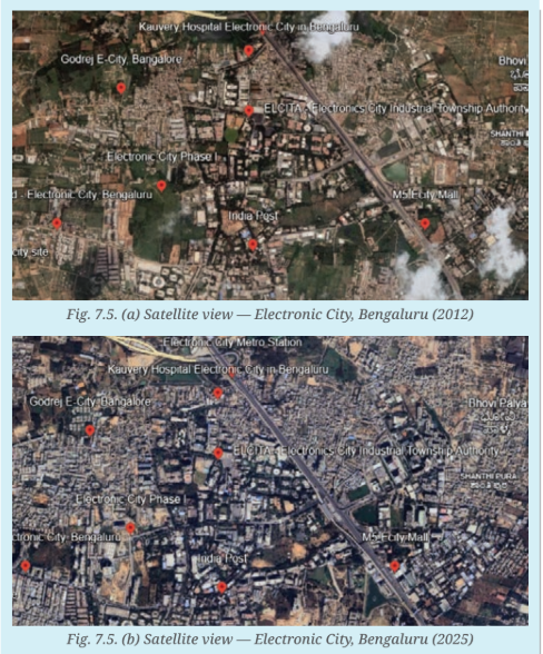
Answer:
Observations: The satellite image from 2025 shows a significant increase in built-up areas (grey blocks) compared to 2012. There are more buildings, roads, and infrastructure, indicating rapid urbanisation. The green patches have decreased.
Causes for the change:
- Rapid economic growth and development, especially in the IT sector.
- In-migration of people from other parts of India for jobs.
- Government policies promoting industrial and IT development.
- Lack of effective urban planning leading to unplanned expansion.
Q3. As a small group project, make a list of adults from different generations in and around your neighbourhood. Draft a questionnaire to enquire into their observations about their own village, town or city and how it has changed over the decades. What, in their view, are the key reasons that towns and cities have changed? If they have grown larger, what are the reasons for this? What do they miss about the 'old days' and what do they appreciate about the current time? Report on your project through a presentation to the class.
Answer:
This is a group project. Students should interview elders from different generations about changes in their city/town. The questionnaire could include questions on changes in population, infrastructure, employment, environment, and lifestyle. The report should summarize findings on reasons for urban growth (e.g., migration, industrialisation), what people miss (e.g., open spaces, community life), and what they appreciate (e.g., better facilities, connectivity).
Q4. What were the reasons that Surat became a textile manufacturing and diamond-cutting hub? (Hint: Recall from your Grade 7 Chapter 'Understanding Markets'.)
Answer:
Surat became a textile manufacturing and diamond-cutting hub due to:
- Its strategic location as a major port on the Arabian Sea, facilitating trade.
- Availability of skilled artisans and labour.
- Access to raw materials and markets.
- Entrepreneurial spirit and investment in the textile and diamond industries.
- Historical development of trade networks and commercial infrastructure.
Q5. Can you name some towns and cities near you? Find out some interesting traditions, cuisines, and customs specific to those areas, and discuss them in class.
Answer:
This is a research activity. Students should identify nearby towns and cities, research their unique traditions, cuisines (e.g., specific dishes), and customs (e.g., festivals, arts, crafts), and present their findings to the class.
Think About It
Q1. Fig. 7.3 shows the satellite view of a village and a city in Haryana, respectively. The larger blocks of green and brown land on the left in the village show open areas, whereas the grey built-up area on the right shows a complex network of buildings. What can you infer about the population density of the two regions? Why do you think such a difference exists? 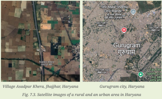
Answer:
The village has a lower population density due to large open spaces (green and brown land), while the city has a higher population density due to the concentration of buildings and infrastructure. The difference exists because the village is primarily agricultural with fewer economic activities, while the city has diverse economic opportunities, industries, and services that attract more people, leading to higher population density.
Q2. Observe the pictures in Fig. 7.18. Do you notice the other side of the city? What could be the possible challenges faced by people living in urban slums? 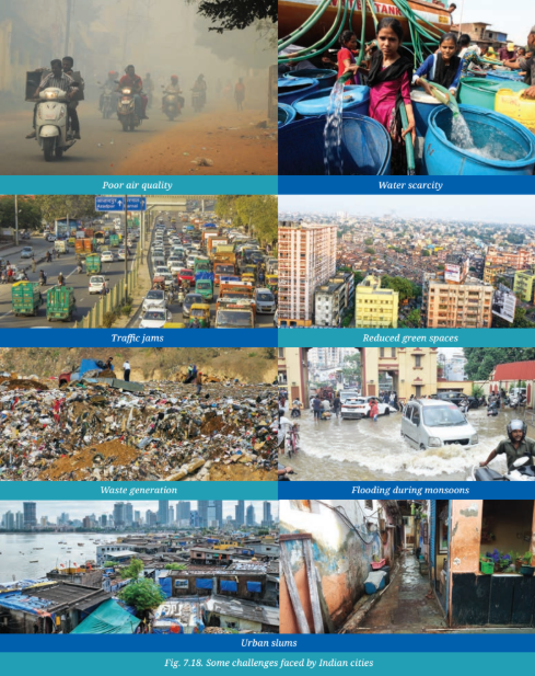
Answer:
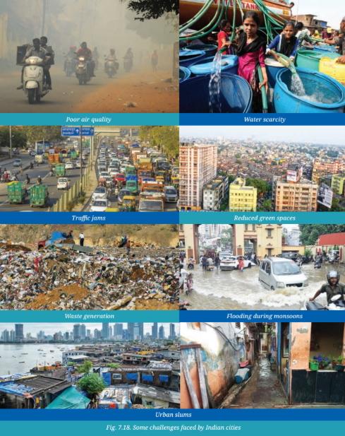
The pictures in Fig. 7.18 show the other side of the city—the slums. Challenges faced by people living in urban slums include:
- Lack of adequate housing and overcrowding.
- Limited access to clean water, sanitation, and electricity.
- Poor health and hygiene leading to diseases.
- Lack of access to quality education and employment.
- Social exclusion and discrimination.
- Vulnerability to eviction, crime, and exploitation.
- Increased risk during natural disasters like floods.
Don't Miss Out
Q1. In 2015, the Government of India launched the Smart Cities Mission. Under this programme, 100 cities were selected to be developed as 'smart cities'. They were to be developed with advanced technology and infrastructure to improve the quality of life for residents. The mission has seen mixed results across different cities and has also been criticised by some experts. While the mission may not have achieved all its objectives, what are some key elements of a smart city?
Answer:
Some key elements of a smart city include:
- Smart Infrastructure: Intelligent transportation systems, efficient energy grids, and robust digital connectivity.
- Sustainable Environment: Green buildings, renewable energy, waste management, and water conservation.
- Digital Governance: E-governance platforms, online grievance redressal, and citizen engagement apps.
- Quality of Life: Affordable housing, healthcare, education, and public safety.
- Economic Development: Support for innovation, startups, and skill development.
- Resilience: Preparedness for natural disasters and climate change.
- Inclusivity: Ensuring that all citizens, including the vulnerable, benefit from urban development.
Questions and Activities
Q1. What are some common features of cities?
Answer:
Common features of cities include:
- High population density and concentration of people.
- Diverse economic activities (industry, services, trade).
- Developed infrastructure (transport, communication, utilities).
- Government institutions and administrative centres.
- Cultural and social diversity.
- Presence of educational, healthcare, and recreational facilities.
- More elaborate transportation and communication systems.
- Often have elected local bodies for governance.
Q2. Can you think of a city or town near you that has grown in population? What could be the underlying reasons for the urban migration?
Answer:
This is a research question. Students can identify a nearby city or town that has grown in population. Reasons for urban migration could include:
- Availability of better employment opportunities (industrialisation, IT sector).
- Better educational facilities and healthcare.
- Infrastructure development (better roads, electricity, connectivity).
- Migration from rural areas due to lack of agricultural employment or natural disasters.
- Social and cultural attractions.
Q3. With reference to the epigraph at the beginning of the chapter, who are the participants in the making of the city and what could be their contribution?
Answer:
The epigraph says, "Cities have the capability of providing something for everybody, only because, and only when, they are created by everybody." Participants in the making of a city include:
- Urban Planners and Architects: Design the city layout, infrastructure, and public spaces.
- Government and Administration: Provide governance, services, and regulations.
- Businesses and Industries: Create jobs, economic activities, and contribute to growth.
- Residents/Citizens: Contribute through their work, participation in community life, and civic engagement.
- Workers and Labourers: Build and maintain the city's infrastructure.
- Artists and Cultural Practitioners: Enrich the city's cultural life.
Q4. In what ways can urbanisation affect rural areas? Do cities also depend on rural areas? If yes, how? In what ways can rural and urban areas help each other develop?
Answer:
Effects of urbanisation on rural areas:
- Migration of young people to cities leads to an ageing population and labour shortage in rural areas.
- Reduced focus on agriculture and local economies.
- Brain drain of educated and skilled individuals.
- Changes in family structures and social dynamics.
Do cities depend on rural areas? Yes, cities depend on rural areas for:
- Food (agricultural produce).
- Raw materials for industries.
- Labour force (migrants).
- Water and other natural resources.
How can rural and urban areas help each other develop?
- Rural areas can supply food and raw materials to cities.
- Cities can provide markets, technology, and services to rural areas.
- Investment in rural infrastructure and education can reduce migration pressure on cities.
- Strengthening rural-urban linkages can promote balanced regional development.
Q5. What is urban planning? What are the risks of ignoring sustainable urban planning as cities expand into villages and forest areas?
Answer:
Urban Planning: It is the process of designing and regulating the use of land, infrastructure, and public spaces in cities to ensure orderly growth, sustainability, and a high quality of life for residents.
Risks of ignoring sustainable urban planning:
- Environmental Degradation: Loss of forests, green spaces, and biodiversity.
- Resource Depletion: Overuse of water, energy, and land.
- Pollution: Increased air, water, and noise pollution.
- Loss of Agricultural Land: Encroachment on fertile farmland, reducing food production.
- Displacement of Communities: Displacement of rural communities and loss of livelihoods.
- Increased Vulnerability: Higher risk of flooding, heatwaves, and other climate-related disasters.
- Inequality: Growth of slums and social exclusion.
Q6. Observe your own neighbourhood. What signs of good or poor planning do you notice? How do they affect daily life for you and others?
Answer:
This is a personal observation activity. Students should look for signs of good planning (e.g., well-maintained roads, parks, streetlights, drainage systems, green spaces) and poor planning (e.g., potholes, broken drainage, lack of footpaths, traffic congestion, garbage piles). They can discuss how these affect their daily life (e.g., commuting, safety, health, leisure).
Q7. Imagine you are an urban planner, what are the things you would consider to plan a city? Do groups like children, senior citizens, and people with disabilities have specific needs?
Answer:
As an urban planner, I would consider:
- Land Use: Zoning for residential, commercial, industrial, and recreational areas.
- Infrastructure: Water supply, sanitation, electricity, waste management, and transportation.
- Housing: Affordable housing for all income groups.
- Environment: Green spaces, pollution control, and climate resilience.
- Social Infrastructure: Schools, hospitals, community centres, and public safety.
- Economic Development: Support for businesses, innovation, and job creation.
- Inclusivity: Design for the needs of all groups, including children, senior citizens, and people with disabilities.
Specific needs of different groups:
- Children: Safe play areas, schools, pedestrian-friendly streets.
- Senior Citizens: Accessible public transport, healthcare facilities, and age-friendly housing.
- People with Disabilities: Ramps, braille signage, accessible public transport, and barrier-free design.
Q8. Suppose your town, village or city has 100 people. Draw a rough map of the place on a graph paper. Imagine each square on the paper represents a specific area of the place, like residential neighbourhoods, parks, schools, factories, post offices and so on. Now, distribute the 100 people throughout the area. You can decide where the people will live, whether they all live in the residential areas, or some live in the commercial or industrial areas. Write this number in each of the boxes. In your depiction of the map, which areas are heavily populated and which are not? What were the reasons behind your choices of allocation of people?
Answer:
This is an activity. Students should draw a grid map of a hypothetical town/city with different zones (residential, commercial, industrial, park, school, etc.). They should allocate a hypothetical population of 100 people to different squares based on logic (e.g., most people live in residential zones, some work in industrial/commercial zones). They should explain why certain areas are more populated (e.g., availability of housing, jobs, proximity to amenities).
Q9. Observe the satellite view of Mumbai and Gangtok, respectively. Find out their population density and likely reasons for the difference.
Answer:
This is a research activity. Mumbai is a large metropolis with a very high population density (over 20,000 people per sq km) due to its status as a financial and commercial hub, limited land, and high in-migration. Gangtok, the capital of Sikkim, has a much lower population density due to its mountainous terrain, smaller economy, and lower migration. Students can find and compare population density data.
Q10. Find out how the city of Beijing, China, tackled the problem of air pollution. Prepare a report outlining measures that can be taken in India to mitigate air pollution in cities.
Answer:
This is a research activity. Beijing tackled air pollution through measures like:
- Shifting industries away from the city.
- Promoting electric vehicles and public transport.
- Implementing strict emission standards.
- Banning the use of coal in urban areas.
- Monitoring air quality and issuing health advisories.
Measures for India:
- Promoting public transport and non-motorized transport.
- Implementing stricter emission norms for vehicles.
- Shifting to cleaner energy sources (solar, wind).
- Controlling industrial emissions and dust.
- Waste management to prevent open burning.
- Increasing green cover and creating urban forests.
- Using technology for real-time monitoring and citizen awareness.
Q11. Talk to a family or community member who has moved from a village to a city. Ask them the reason for the same and their experience, challenges and opportunities. How does city life compare to rural life?
Answer:
This is an interview activity. Students should interview someone who has migrated from a village to a city. They can ask about reasons for migration (e.g., jobs, education, family), their experiences, challenges (e.g., housing, language, cost of living), and opportunities (e.g., better jobs, education, healthcare). They can also discuss the differences between city and rural life in terms of lifestyle, pace, and social connections.
Q12. Learn about urban planning in other cities around the world. In what ways can some of those aspects be adapted for a city near you?
Answer:
This is a research activity. Students can study urban planning models from cities like Singapore (vertical gardens, mixed-use spaces, public transport), Copenhagen (cycling infrastructure), or Curitiba, Brazil (Bus Rapid Transit). They can then suggest how these approaches could be adapted to their local city/town.
Q13. Explore and suggest action points with respect to urban planning in cities to mitigate the challenges below and write a report. Two have been completed for you. Waste Management: Conducting a 'Segregate at Source' awareness drive in residential areas with demos on dry/ wet waste disposal and composting. Traffic congestion: carpooling, high taxes on vehicle purchase, etc. Inadequate safety of residents Poor mobility within the city Expansion of slums Heat waves during summers
Answer:
This is a creative and problem-solving activity. Students should suggest action points for each challenge.
Inadequate safety of residents: Installing more streetlights, CCTV cameras in public spaces, increasing police patrolling, creating community watch groups, and ensuring well-designed public spaces for safe movement.
Poor mobility within the city: Expanding and improving public transport (metros, buses, BRTS), creating dedicated cycling and pedestrian paths, introducing carpooling and ride-sharing apps, and ensuring last-mile connectivity.
Expansion of slums: Implementing slum rehabilitation programs, providing affordable housing (e.g., PM Awas Yojana), improving basic services (water, sanitation, electricity) in slums, and providing skills training and employment opportunities.
Heat waves during summers: Increasing green cover and creating urban forests, using reflective materials for roofs and roads, promoting vertical gardens and green roofs, building water bodies for cooling, and encouraging the use of energy-efficient air conditioning.
Q14. Find out about a slum rehabilitation program where people moved from slums to proper housing in your city. What do you think its possible benefits could be for the communities there?
Answer:
This is a research activity. Students can research a slum rehabilitation program (e.g., Dharavi redevelopment in Mumbai, or similar programs in other cities). Benefits could include:
- Improved living conditions with access to clean water, sanitation, and electricity.
- Better health and hygiene.
- Access to education and healthcare facilities.
- Increased economic opportunities and reduced crime.
- Dignity and social inclusion.
- Better preparedness for disasters.