
The Big Questions
Q1. What are the unique physical features of the continents?
Answer:
Each continent has unique physical features:
- Asia: The Tibetan Plateau (the highest and largest plateau), the Himalayas, the Gobi Desert, and the Eurasian Steppes.
- Europe: The European Plain (one of the largest flatlands), the Alps mountain range, and the Ural Mountains (which form a natural boundary between Europe and Asia).
- Africa: The Sahara Desert (the largest hot desert), the African Savannah, and the River Nile (the longest river in the world).
- South America: The Andes Mountains (the longest continental mountain range), the Amazon Rainforest (the 'Lungs of the Earth'), and the Atacama Desert (one of the driest places on Earth).
- North America: The Colorado Plateau (featuring the Grand Canyon), the Rocky Mountains, the Appalachian Mountains, and the Great Lakes.
- Australia: The Great Australian Desert (a large arid region).
- Antarctica: The largest and coldest desert on Earth, covered in ice.
Q2. Why do we need to understand world geography?
Answer:
Understanding world geography is important because:
- Interconnectedness: The world is interconnected; events in one region can affect others (e.g., ocean currents influence global climate).
- Environmental Awareness: It helps us understand global environmental issues like climate change, deforestation, and pollution, and their impact on biodiversity and human life.
- Resource Management: It helps us understand the distribution of natural resources (water, minerals, energy) and the need for sustainable use.
- Cultural Appreciation: It fosters appreciation for the diversity of cultures, ecosystems, and landscapes around the world.
- Informed Global Citizenship: It equips us with knowledge to be responsible global citizens and to make informed decisions about issues affecting our planet.
Q3. How do human actions trigger environmental issues?
Answer:
Human actions trigger environmental issues in several ways:
- Deforestation: Clearing forests for agriculture, logging, and development leads to loss of biodiversity, soil erosion, and climate change.
- Pollution: Industrial and agricultural waste, plastic, and chemical runoff pollute water bodies, soil, and air, harming ecosystems and human health.
- Climate Change: Burning fossil fuels releases greenhouse gases, causing global warming, melting ice caps, rising sea levels, and extreme weather events.
- Overfishing: Unsustainable fishing practices deplete fish stocks and disrupt marine food chains.
- Fast Fashion: The production and disposal of cheap clothing lead to pollution and waste (e.g., the Atacama Desert becoming a dump for discarded clothes).
- Agricultural Runoff: Fertilizers and pesticides from farms contaminate water bodies, causing algal blooms and harming aquatic life.
Let's Explore
Q1. What do you think each of the different colours in the map in Fig. 1.1 represents? Since this chapter is about world geography, we are concerned with physical maps. Physical maps have their own language that use colours - Blue: water bodies (oceans, seas, lakes, rivers); Green: plains; Yellow/Brown: plateaus; Dark brown: high mountains; Light yellow: deserts; White: ice and glaciers 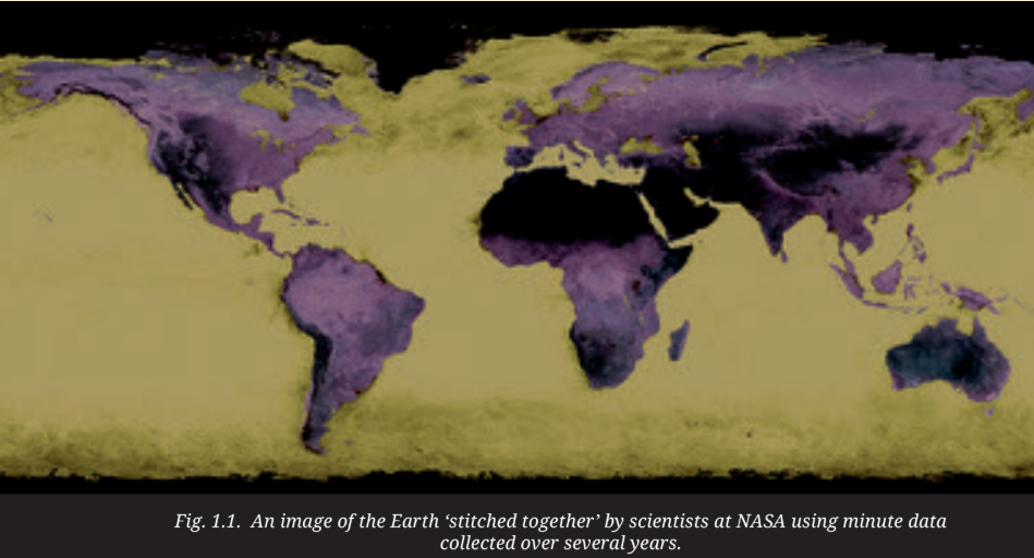
Answer:
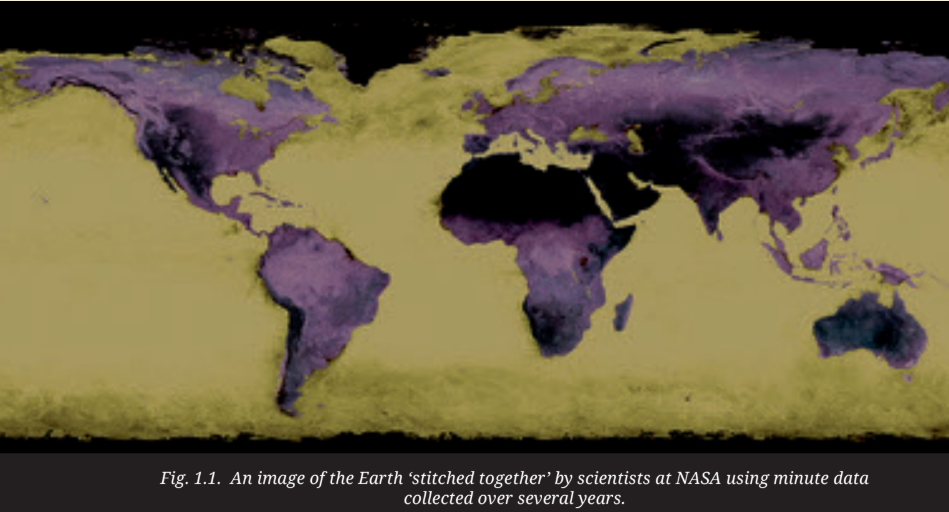
The colours in physical maps represent different landforms and water bodies. Blue indicates water bodies like oceans, seas, lakes, and rivers. Green represents plains, which are low-lying flat areas. Yellow or brown indicates plateaus, which are elevated flat areas. Dark brown represents high mountains. Light yellow indicates deserts, which are dry, arid regions. White represents ice and glaciers, found in polar regions and on high mountains.
Q2. Study the map in Fig.1.11. What are the different physical features represented here? (Hint: You may refer to LET'S EXPLORE on page 2 of this chapter.) 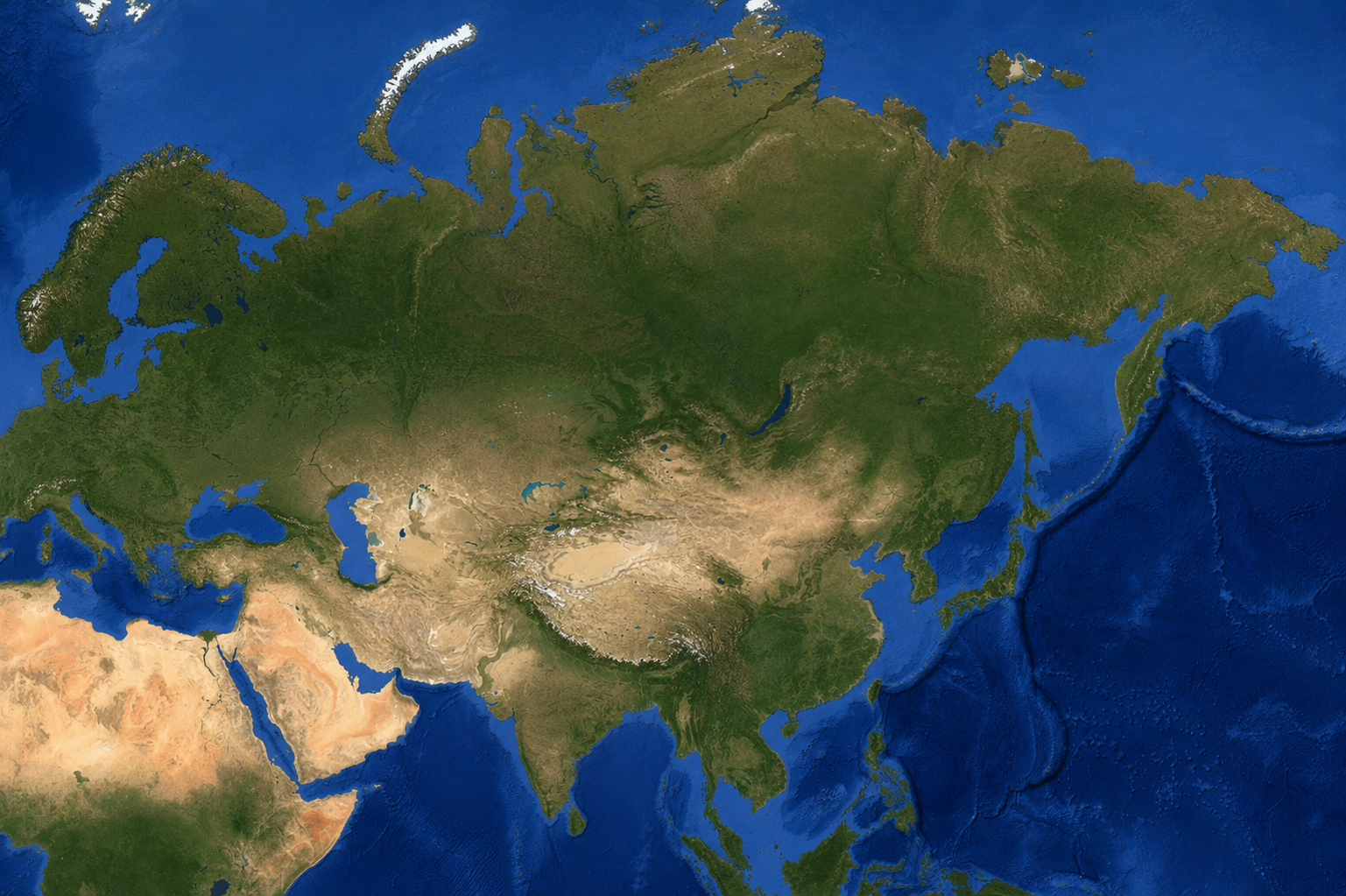
Answer:
The physical map of Asia (Fig. 1.11) shows various physical features including:
- Mountains: Himalayas, Ural Mountains.
- Plateaus: Tibetan Plateau, Deccan Plateau.
- Deserts: Gobi Desert, Thar Desert.
- Plains: Indo-Gangetic Plains, West Siberian Plain, North China Plain.
- Water Bodies: Oceans (Pacific, Indian, Arctic), Seas (Arabian Sea, South China Sea), and major rivers (Indus, Ganges, Brahmaputra, Yangtze, Mekong).
Q3. Assess and describe the Himalayas from the perspective of these different roles.
Answer:
The Himalayas play several crucial roles:
- Climate Determinant: They block cold winds from Central Asia, creating a monsoon climate in South Asia, and influence the region's weather patterns.
- Water Towers: They are the source of major rivers like the Indus, Ganges, and Brahmaputra, providing fresh water through snow and glacier melt to billions of people.
- Biodiversity Hotspots: They host diverse ecosystems with unique flora and fauna, many of which are endemic to the region.
- Natural Boundary: They form a natural barrier between South Asia and East Asia, historically shaping cultural and political interactions.
- Cultural and Spiritual Significance: They are sacred in Hinduism, Buddhism, and other traditions, and hold deep cultural importance.
Q4. Observe the area covered by the European Plain. Now turn to the political map of the world at the end of this textbook. List the countries that are part of the European Plain (you need not memorise them).
Answer:
The European Plain covers parts of several countries, including (but not limited to) France, Belgium, the Netherlands, Germany, Poland, Ukraine, Belarus, Russia, and parts of the UK. It stretches from the Bay of Biscay and the English Channel in the west to the Ural Mountains in the east.
Q5. On the map (Fig. 1.22) locate the course of the River Nile. Where does it originate from and in which direction does it flow? Turn to the political map at the end of the book, and identify some of the areas that the river flows through. 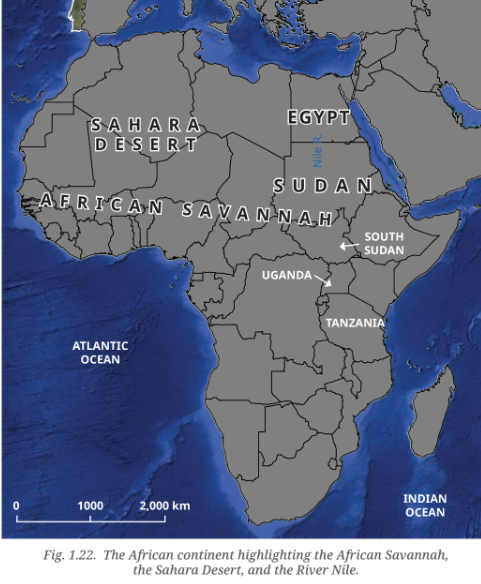
Answer:
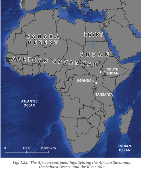
The River Nile originates from Lake Victoria in East Africa (though its farthest source is the Kagera River in Rwanda). It flows northwards through Uganda, South Sudan, Sudan, and Egypt, before draining into the Mediterranean Sea. It is the longest river in the world.
Q6. The Amazon Rainforest has been called the 'Lungs of the Earth'. Why do you think this might be so? The countries in this region need land for development but risk losing the Amazon Rainforest. Discuss in groups: What are the short and long-term effects of deforestation, and how can we protect the Amazon for the planet?
Answer:
The Amazon Rainforest is called the 'Lungs of the Earth' because it produces a significant amount of the world's oxygen and absorbs large amounts of carbon dioxide, helping to regulate the global climate.
Short-term effects of deforestation:
- Loss of habitat for wildlife.
- Soil erosion and degradation.
- Release of stored carbon into the atmosphere.
- Impact on local communities and indigenous people.
Long-term effects of deforestation:
- Climate change acceleration.
- Loss of biodiversity and extinction of species.
- Disruption of the water cycle and reduced rainfall.
- Irreversible damage to the global ecosystem.
How to protect the Amazon:
- Sustainable land-use practices and reforestation.
- Strengthening environmental laws and enforcement.
- Supporting indigenous communities' rights and conservation efforts.
- Reducing consumer demand for products linked to deforestation (e.g., beef, soy, palm oil).
- International cooperation and funding for conservation.
Q7. The Atacama Desert is famous for stargazing, offering some of the clearest night skies, and its rocky, Mars-like landscape has even been used by NASA to test rovers. However, it has also become one of the world's fastest-growing dumps for discarded clothes, caused by the rise of cheap fast fashion. The UN has called this waste problem 'an environmental and social emergency'.
Answer:
This is a discussion point. The Atacama Desert's unique location and climate make it ideal for stargazing and scientific research. However, the fast fashion waste problem is a serious environmental and social issue. Discarded clothes release pollutants and microplastics as they decompose, harming the fragile desert ecosystem. This highlights the global impact of consumerism and the need for sustainable production and consumption practices. Solutions include promoting circular fashion (reuse, recycling), reducing textile waste, and supporting ethical and sustainable brands.
Think About It
Q1. Oceans give us almost half the oxygen we breathe. Tiny marine organisms, such as plankton, make this possible. What do you think would happen to all living beings if pollution harmed these plankton, and they could no longer produce enough oxygen?
Answer:
If pollution harmed plankton and they could no longer produce enough oxygen, the consequences would be catastrophic for all living beings:
- Reduced Oxygen: A significant decrease in oxygen levels would make it difficult for all aerobic life (including humans) to survive.
- Disruption of Food Chains: Plankton is the base of the marine food web. Their loss would cause a collapse of fish stocks and other marine life, affecting food security for billions of people.
- Climate Change Acceleration: Plankton also absorbs carbon dioxide. Their loss would exacerbate global warming and climate change.
- Ocean Acidification: Pollution can lead to ocean acidification, harming shell-forming organisms and further disrupting the ecosystem.
Questions and Activities
Q1. Why do all map projections have some amount of distortion?
Answer:
All map projections have some distortion because the Earth is a three-dimensional oblate spheroid (a sphere that bulges at the equator), and it is impossible to perfectly represent a curved surface on a two-dimensional flat surface without distorting some aspect of it. This is like trying to peel an orange and lay the peel flat without tearing it; you will always get some stretching or tearing. Different map projections preserve certain properties (like shape, area, or direction) while distorting others. The Mercator projection, for example, preserves shape and direction but distorts size, especially near the poles.
Q2. What makes the Tibetan Plateau unique?
Answer:
The Tibetan Plateau is unique because:
- It is the highest and largest plateau on Earth. It has an average height of over 4,500 metres above sea level.
- It is the result of tectonic plate collisions. Its formation is linked to the collision between the Indo-Australian and Eurasian plates, which also created the Himalayas.
- It is known as the 'Third Pole'. It contains the largest reserves of freshwater outside the polar regions, stored in its glaciers and snow.
- It is the source of major rivers. It feeds the Indus, Brahmaputra, and Yangtze rivers, providing water for millions of people.
- It influences the climate of Asia. Its high altitude and massive size affect weather patterns, including the monsoon system.
Q3. Why are coral reefs called the 'rainforests of the sea'?
Answer:
Coral reefs are called the 'rainforests of the sea' because they are among the most diverse ecosystems on Earth. They provide food and shelter for about one-quarter of all ocean species, including fish, crabs, turtles, and sponges. They support a vast array of life, just like tropical rainforests do on land, with a complex web of interdependence and high biodiversity.
Q4. How do the oceans help to regulate the Earth's climate?
Answer:
Oceans help regulate the Earth's climate in several ways:
- Absorbing Heat: They absorb solar radiation and store heat, then slowly release it over time, moderating temperatures on land.
- Absorbing Carbon Dioxide: They absorb a large amount of CO2 from the atmosphere, reducing the greenhouse effect.
- Ocean Currents: They distribute heat around the globe through currents (like the Gulf Stream), which transfer warm water to cooler regions and cold water to warmer regions, influencing regional climates.
- Adding Moisture to Air: They evaporate water, adding moisture to the air, which forms clouds and precipitation, affecting weather patterns globally.
Q5. What is the main reason for the Great Barrier Reef facing threats today?
Answer:
The Great Barrier Reef faces threats primarily from human activities, including:
- Climate Change: Rising sea temperatures cause coral bleaching, where corals expel the algae living in their tissues and turn white, leading to their death.
- Pollution: Agricultural runoff, industrial waste, and plastic pollution harm the reef's health.
- Overfishing: Unsustainable fishing practices disrupt the food chain and damage the reef's ecosystem.
- Ocean Acidification: Increased CO2 in the atmosphere dissolves in the ocean, making the water more acidic and harming coral growth and the shells of marine organisms.
Q6. Why is the Amazon Rainforest often called the 'Lungs of the Earth'?
Answer:
The Amazon Rainforest is called the 'Lungs of the Earth' because it produces a significant portion of the world's oxygen (approximately 20%) and plays a crucial role in absorbing carbon dioxide. The vast number of trees and plants in the forest perform photosynthesis, releasing oxygen and absorbing CO2, helping to regulate the global climate and maintaining the balance of gases in the atmosphere.
Q7. Choose two different types of geographical features you have explored in this chapter. Write short paragraphs on how they influence the flora and fauna or human lives in that area. Do they also have an implication for the whole globe?
Answer:
1. The Amazon Rainforest: The Amazon Rainforest is a biodiversity hotspot, home to millions of species of plants, animals, and insects. It provides habitat, food, and medicine for both wildlife and local communities. Human lives in the region depend on the forest for their livelihood, food, and cultural identity. Globally, the Amazon plays a crucial role in regulating the Earth's climate by absorbing carbon dioxide and producing oxygen. Its destruction would accelerate climate change and lead to loss of biodiversity, affecting the entire planet.
2. Coral Reefs: Coral reefs are rich in marine life, providing food and shelter for about a quarter of all ocean species, including fish, turtles, and crustaceans. They support fisheries, which provide protein for billions of people globally, and are vital for coastal protection by absorbing wave energy. Human lives are sustained by the resources they provide and tourism. Globally, coral reefs are indicators of ocean health. Their degradation due to bleaching and pollution signals a wider environmental crisis, and their loss would have severe implications for global biodiversity and the food chain.
Q8. Discuss how oceans influence climate and trade. Use examples from the Indian and Pacific Oceans.
Answer:
Climate: Oceans influence climate through currents and wind patterns. The Indian Ocean, for example, plays a major role in the monsoon system that brings rainfall to South Asia. The warm waters of the Indian Ocean drive the monsoon winds, which are essential for agriculture. The Pacific Ocean influences climate through phenomena like El Niño and La Niña, which can cause extreme weather events like floods and droughts globally.
Trade: Oceans are major routes for international trade. The Indian Ocean has been a vital trade corridor for millennia, connecting India, East Africa, the Middle East, and Southeast Asia. Today, the Indian Ocean carries a large share of the world's maritime trade, including oil and gas. The Pacific Ocean is crucial for trade between Asia and the Americas. The Strait of Malacca (connecting the Indian and Pacific Oceans) is a key chokepoint for trade, especially energy resources, highlighting the strategic and economic importance of these ocean routes.
Q9. Choose one environmental issue (deforestation, reef bleaching, or desertification) and explain its causes, impacts, and possible solutions.
Answer:
Issue: Deforestation (in the Amazon Rainforest)
Causes: Deforestation in the Amazon is primarily driven by:
- Agricultural expansion (clearing land for cattle ranching and soy production).
- Logging (for timber).
- Infrastructure development (roads, dams).
- Mining.
Impacts:
- Loss of biodiversity (species extinction).
- Climate change (release of stored carbon).
- Disruption of the water cycle, leading to reduced rainfall.
- Displacement of indigenous communities and loss of their livelihoods.
- Soil erosion and degradation.
Possible Solutions:
- Strengthen and enforce environmental laws and protected areas.
- Promote sustainable agriculture and land-use practices.
- Support indigenous land rights and community-led conservation.
- Reduce consumer demand for products linked to deforestation (e.g., choose sustainable beef, soy, and timber).
- International cooperation and financing for reforestation and conservation programs.
Q10. Imagine you are a geographer asked to advise a government about protecting one major landscape in your country. Which one would you choose, and why?
Answer:
This is a reflective question. Students should choose a major landscape in their country (e.g., the Himalayas, the Western Ghats, the Sundarbans) and justify their choice based on its ecological, economic, and cultural significance. For example, a student might recommend protecting the Himalayas because they are a water tower, source of major rivers, biodiversity hotspot, and have cultural significance.
Q11. Imagine that someone is funding a group of you for a road trip across two continents. There are differences of opinion on which two they should be. Make a pitch for the ones you would like everyone to go to. Use a blank map, trace your route and locate the places on it, and try to convince the others to your point of view. You could use a variety of creative ways.
Answer:
This is a creative and group activity. Students can choose two continents (e.g., South America and Africa) and design a road trip. They can trace their route on a blank map, highlighting key geographical features (like the Amazon Rainforest, the Andes Mountains, the Sahara Desert, and the Nile River) and cultural/historical sites (like Machu Picchu, the pyramids of Egypt, or the Great Rift Valley). The pitch should be persuasive, focusing on the natural wonders, cultural experiences, and diversity they would encounter.