
Page 1 - The Big Questions
Q1.
What is the composition of the atmosphere?
Answer:
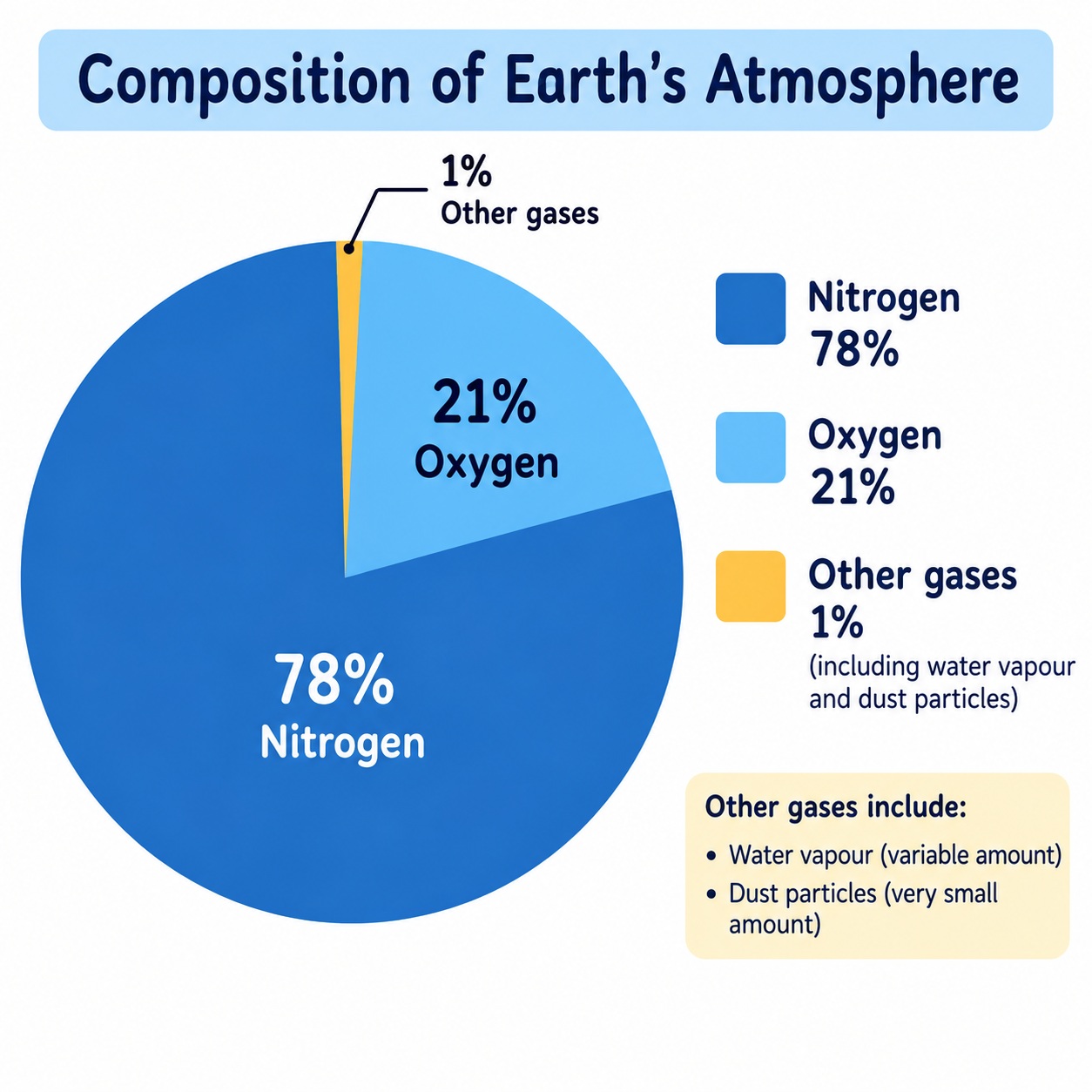
The Earth's atmosphere is composed of a mixture of various gases. The two primary gases are nitrogen (78%) and oxygen (21%). Other gases present in smaller quantities include argon (0.93%), carbon dioxide (0.04%), and traces of helium, neon, krypton, xenon, ozone, and hydrogen. The atmosphere also contains water vapour (ranging from 0.1% to 0.4%) and tiny dust particles. The composition varies with altitude. A pie diagram would show nitrogen as the largest slice, followed by oxygen, with a tiny sliver for other gases.
Pie diagram representation:
- Nitrogen: 78%
- Oxygen: 21%
- Argon: 0.93%
- Carbon Dioxide: 0.04%
- Others: 0.03%
Q2.
How do the different layers of the atmosphere affect the planet Earth?
Answer:
The atmosphere has five major layers, each affecting the Earth differently:
- Troposphere (up to 12 km): Contains the air we breathe, water vapour, clouds, and all weather phenomena (rain, fog, hail). Temperature decreases with altitude.
- Stratosphere (12–50 km): Contains the ozone layer which filters harmful ultraviolet radiation. It is free of clouds, making it ideal for aeroplanes.
- Mesosphere (50–80 km): Most meteorites burn up here. Temperature decreases with altitude.
- Thermosphere (80–700 km): Temperature rises rapidly due to absorption of X-rays and ultraviolet radiation. It helps in radio transmission and hosts auroras (northern and southern lights).
- Exosphere (above 700 km): Very thin air; light gases like helium and hydrogen float into space.
Collectively, these layers regulate Earth's temperature, protect from harmful radiation, enable weather, and support life.
Q3.
What is the mechanism of monsoon?
Answer:
Monsoon refers to the seasonal reversal in wind direction. India experiences two main monsoons:
- South-west monsoon (Summer monsoon) – from June to September. During summer, the landmass of India heats up faster than the surrounding oceans, creating a low?pressure area over land and high pressure over the sea. Moist winds blow from the sea to the land, bringing heavy rainfall to most parts of India.
- North-east monsoon (Winter monsoon) – from October to February. In winter, the land cools faster, creating high pressure over land and low pressure over the sea. Cold, dry winds blow from land to sea. However, when these winds pass over the Bay of Bengal, they pick up moisture and cause rainfall in the eastern coast (Tamil Nadu, Andhra Pradesh, Karnataka).
The monsoon is vital for agriculture, water supply, and the economy of India.
Q4.
How can we reduce our carbon footprint?
Answer:
Carbon footprint is the total amount of greenhouse gases released into the atmosphere due to human activities. We can reduce it by:
- Transport: Walking, cycling, using public transport, carpooling, and avoiding unnecessary flights.
- Electricity use: Switching off appliances when not in use, using energy?efficient devices, and adopting renewable energy sources like solar.
- Water use: Using water judiciously (e.g., one bucket for bathing, fixing leaks).
- Waste management: Reusing, recycling, and avoiding single?use plastics.
- Planting trees: Afforestation and protecting forests.
- Adopting sustainable lifestyles – consuming less, supporting eco?friendly products, and spreading awareness.
Page 1 - THINK ABOUT IT (No Atmosphere)
Q1.
Can you imagine what would happen if there were no atmosphere? Discuss your thoughts with your friends and teachers.
Answer:
If there were no atmosphere, life on Earth would be impossible. Key consequences would include:
- No protection from harmful solar radiation – ultraviolet rays would reach the surface, causing severe damage to living organisms.
- Extreme temperature variations – the atmosphere traps heat (greenhouse effect) and moderates temperatures. Without it, days would be scorching hot and nights freezing cold.
- No weather phenomena – no rain, clouds, or wind; water cycle would cease.
- No air to breathe – oxygen and nitrogen would be absent.
- No sound – sound needs a medium to travel.
Thus, the atmosphere is essential for all life forms and the planet's climate stability.
Page 2 - LET'S RECALL (Nitrogen)
Q1.
How is nitrogen useful for plants?
Answer:
Nitrogen is an essential nutrient for plants. It is a key component of chlorophyll (the pigment that enables photosynthesis) and proteins, which are vital for plant growth and development. Although the atmosphere contains 78% nitrogen, plants cannot directly use it. They rely on nitrogen-fixing bacteria (found in soil and root nodules of legumes) to convert atmospheric nitrogen into usable forms like nitrates and ammonium. This process is part of the nitrogen cycle, which sustains plant life and, consequently, all food chains.
Page 7 - THINK ABOUT IT (Strong Winds)
Q1.
Find out other categories of wind based on speed and their common effects, and share your findings in class.
Answer:
Based on the Beaufort scale, winds are categorised by speed. Here are some additional categories:
Wind Speed (km/hr)CategoryCommon Effects1–5Light airSmoke drift indicates wind direction; leaves barely move.12–19Gentle breezeLeaves and small twigs in constant motion; wind extends light flag.20–28Moderate breezeRaises dust and loose paper; small branches move.29–38Fresh breezeSmall trees sway; waves form on inland water.50–61Near galeWhole trees in motion; difficulty walking against wind.62–74GaleTwigs break off; slight structural damage.75–88Strong galeTiles blown off; large branches break.89–102StormWidespread damage to buildings and trees.>118HurricaneCatastrophic damage; complete destruction.
Page 8 - LET'S EXPLORE (Wind Categories)
Q1.
Note down the weather report from a local newspaper for two weeks and observe the changes occurring in the weather.
Answer:
Activity: Record daily weather data (temperature, humidity, rainfall, wind speed, etc.) from a newspaper or weather app for two weeks. Observe patterns such as increasing temperatures, sudden rainfall, or changes in wind direction. At the end, summarise the weather trends – for example, "First week was sunny with temperatures around 30°C; second week saw cloudy skies and light rain." Discuss how these changes relate to seasons and local climate. This exercise helps understand day-to-day weather variability versus long-term climate.
Page 9 - LET'S ANALYSE (Weather Report)
Q1.
To what extent did natural factors cause these floods compared to human activities?
Answer:
Both natural and human factors contributed. Natural causes included heavy monsoon rains intensified by western disturbances, and pre?existing high water levels in rivers. Human?made causes included weak and old embankments, encroachment on river floodplains, silt accumulation reducing river capacity, and inadequate early warning systems. While the rains were extreme, the damage was exacerbated by human actions. Proper planning and infrastructure could have significantly reduced the impact, so human activities played a substantial role in aggravating the disaster.
Page 10 - THINK ABOUT IT (Ragas and Seasons)
Q1.
What is atmosphere? Explain its composition with the help of a pie diagram.
Answer:
The atmosphere is the blanket of air surrounding the Earth, held by gravity. It is composed mainly of nitrogen (78%) and oxygen (21%), with smaller amounts of argon (0.93%), carbon dioxide (0.04%), and traces of other gases, water vapour, and dust particles. The composition varies with altitude.
Pie diagram representation:
- Nitrogen: 78%
- Oxygen: 21%
- Argon: 0.93%
- Carbon Dioxide: 0.04%
- Others: 0.03%
Page 14 - LET'S EXPLORE (Monsoon Impact)
Q1.
Describe in your own words how monsoon affects the lives of the people around you.
Answer:
How monsoon affects the lives of people:
Positive Impacts:
- Agriculture: Farmers depend on monsoon rain for sowing and growing crops. A good monsoon means a good harvest and higher income for farmers
- Water Supply: Rain fills rivers, reservoirs, and wells, ensuring water supply for drinking and irrigation throughout the year
- Cooling Effect: Rain brings relief from the intense summer heat and cools the environment
- Festivals: Many festivals like Teej, Onam, and Raksha Bandhan are celebrated during the monsoon season
- Employment: Monsoon-related agricultural activities provide employment to many people in rural areas
Negative Impacts:
- Floods: Excessive rainfall can cause floods, damaging crops, houses, and infrastructure
- Waterlogging: Roads get waterlogged, causing traffic jams and inconvenience
- Health Issues: Waterborne diseases like dengue, malaria, and cholera spread during the monsoon
- School Disruptions: Heavy rains often lead to school closures
- Transport: Trains and flights get delayed or cancelled due to bad weather
Overall Impact: Monsoon is the lifeblood of India, affecting agriculture, economy, daily life, and culture. While it brings joy and prosperity, it also brings challenges that communities must face together.
Page 15-16 - LET'S EXPLORE (Carbon Footprint)
Q1.
My Carbon Footprint
Step 1: My Daily Habits — Tick the options that best describe you.
A. Transport
☐ I usually walk/use a cycle. (Low impact)
☐ I use public transport/carpool. (Medium impact)
☐ I travel by private cars even for short distances. (High impact)
☐ I take flights more than twice a year. (Very high impact)
B. Electricity Use
☐ I always switch off electrical appliances (lights, fans, etc.) when not in use. (Low impact)
☐ I sometimes forget to switch off electrical appliances. (Medium impact)
☐ I leave electrical appliances on frequently. (High impact)
C. Water Use
☐ I use water judiciously, for example, just one bucket of water for bathing. (Low impact)
☐ I sometimes waste water (leaving the tap running/more buckets for bath/long showers). (Medium impact)
☐ I rarely think about saving water. (High impact)
D. Waste and Plastics
☐ I reuse, recycle, and avoid single-use plastics. (Low impact)
☐ I sometimes use disposable plastics (bottles/bags/straws). (Medium impact)
☐ I often throw away plastic and do not recycle. (High impact)
Step 2: Score Yourself
Low impact choices = 1 point
Medium impact choices = 2 points
High impact choices = 3 points
Very high impact choices = 4 points
Now add up your total score: _____ points
Step 3: My Climate Action Pledge
Think about two simple changes you can make to reduce your score, and write them down below.
1. ___________
2. ___________
Answer:
Sample Response — Carbon Footprint Assessment:
My Score:
- Transport: I usually walk/use a cycle = 1 point
- Electricity Use: I always switch off appliances = 1 point
- Water Use: I use water judiciously = 1 point
- Waste and Plastics: I reuse, recycle, and avoid single-use plastics = 1 point
- Total Score: 4 points (Low impact)
My Climate Action Pledge:
Change 1: I will plant at least one tree every month and encourage my friends to do the same.
Change 2: I will start a 'No Plastic Day' in my neighbourhood once a week to reduce plastic waste.
Alternative Sample (Higher Score):
- Transport: Travel by private car = 3 points
- Electricity: Sometimes forget to switch off = 2 points
- Water: Sometimes waste water = 2 points
- Waste: Sometimes use disposable plastics = 2 points
- Total Score: 9 points (Medium-High impact)
Pledge for Higher Score:
Change 1: I will use public transport or carpool at least twice a week to reduce my carbon footprint.
Change 2: I will carry a reusable water bottle and shopping bag to avoid single-use plastics.
Pages 19-21 - Questions and Activities
Q1.
What is atmosphere? Explain its composition with the help of a pie diagram.
Answer:
What is Atmosphere?
The atmosphere is a blanket of air surrounding the Earth, pulled down by gravity. It is a mixture of gases in various proportions, vital for the survival of all living beings. The atmosphere shields us from harmful radiation, regulates temperature, and is key to weather and climate systems.
Composition of the Atmosphere:
- Nitrogen: 78% — most abundant gas, essential for plants
- Oxygen: 21% — second most abundant, essential for life
- Other Gases: 1% — includes argon, carbon dioxide, helium, neon, krypton, xenon, ozone, hydrogen
- Water Vapour: 0.1% to 0.4% — varies with location and weather
- Dust Particles: Tiny particles suspended in the air
Q2.
Draw a labelled diagram of the structure of atmosphere.
Answer:
Structure of the Atmosphere (from Earth's surface to outer space):
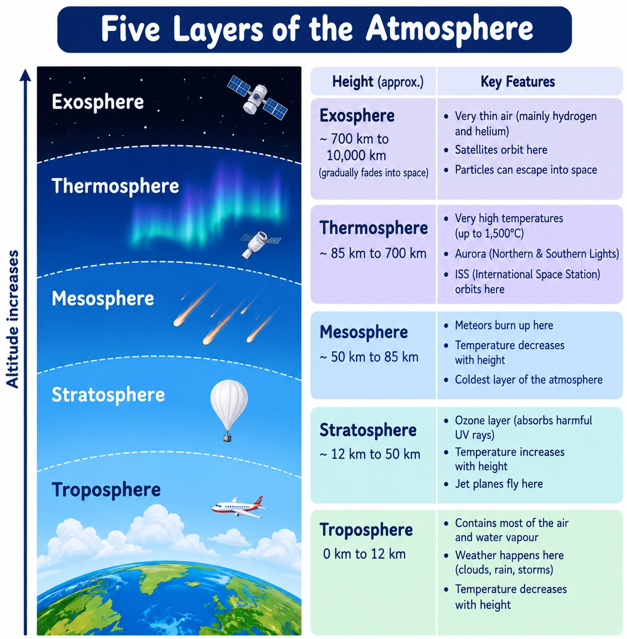
- Troposphere (0-12 km):
- Contains air we breathe, water vapour, clouds
- All weather phenomena occur here
- Temperature decreases with altitude
- Separated from stratosphere by tropopause
- Stratosphere (12-50 km):
- Free of clouds and weather disturbances — ideal for aeroplanes
- Contains the ozone layer
- Separated from mesosphere by stratopause
- Mesosphere (50-80 km):
- Most meteorites burn up here
- Temperature decreases with altitude
- Thermosphere (80-700 km):
- Temperature rises rapidly
- Contains ionosphere
- Auroras occur here
- Helps with radio transmission
- Exosphere (Above 700 km):
- Uppermost layer
- Very thin air
- Light gases (helium, hydrogen) escape into space
Q3.
Which are the four main seasons of India?
Answer:
The four main seasons of India according to the Indian Meteorological Department (IMD):
- Winter (December to early April):
- Coldest months: December and January
- Average temperature in northwest: 10-15°C
- Temperature increases towards the equator: 20-25°C
- Summer or Pre-monsoon (April to June):
- Hottest month in west/south: April
- Hottest month in north: May
- Average temperature in inland India: 32-40°C
- Monsoon or Rainy (June to September):
- Dominated by humid south-west summer monsoon
- Sweeps across country in late May or early June
- Rain begins to recede from north India in October
- Post-monsoon (October to December):
- Also called retreating monsoon
- October and November usually cloudless in northwest India
- South India typically receives more rainfall during this time
Note: Himalayan states experience two additional seasons — autumn and spring.
Q4.
Why do you not feel the pressure of the atmosphere?
Answer:
We do not feel atmospheric pressure because:
- Air presses from all sides: The air above us exerts pressure on our bodies, but air also presses from below and from the sides equally
- Our bodies exert counter-pressure: The pressure inside our bodies is equal to the atmospheric pressure and cancels the pressure from outside
- Equal distribution: Atmospheric pressure is exerted evenly on all parts of our body, so we don't feel it
- Adaptation: Our bodies have evolved to function under normal atmospheric pressure
- Changes are felt: We do feel pressure changes when altitude changes — like in aeroplanes or mountains (ear popping)
Q5.
In which layer of the atmosphere do aeroplanes fly and why?
Answer:
Aeroplanes fly in the stratosphere layer of the atmosphere.
Reasons for flying in the stratosphere:
- Free of Weather Disturbances: The stratosphere is free of clouds, storms, and other weather phenomena that occur in the troposphere
- Smooth Flight: The air is calm and stable, providing a smooth flying experience
- Less Turbulence: There is less turbulence compared to the troposphere
- Fuel Efficiency: The thinner air creates less drag, making flights more fuel-efficient
- Safety: Flying above weather disturbances reduces the risk of accidents
- Distance: The stratosphere extends up to 50 km, providing ample space for air traffic
Q6.
Distinguish between the following:
a. The troposphere and stratosphere
Answer:
Differences between Troposphere and Stratosphere:
| Aspect | Troposphere | Stratosphere |
|---|---|---|
| Height | 0 to 12 km | 12 to 50 km |
| Temperature | Decreases with altitude | Increases with altitude |
| Weather | All weather phenomena occur here | Free of weather disturbances |
| Clouds | Contains clouds and water vapour | Cloud-free |
| Importance | Contains air we breathe | Contains ozone layer |
| Aviation | Not ideal for flying | Ideal for aeroplanes |
| Boundary | Separated by tropopause | Separated by stratopause |
Q7.
b. The south-west monsoon and north-east monsoon
Answer:
Differences between South-West Monsoon and North-East Monsoon:
| Aspect | South-West Monsoon | North-East Monsoon |
|---|---|---|
| Season | Summer monsoon | Winter monsoon |
| Time | June to September | October to February |
| Wind Direction | From sea to land | From land to sea |
| Cause | Land heats faster than sea; low pressure over land | Land cools faster than sea; high pressure over land |
| Wind Nature | Moist winds | Cold and dry winds |
| Rainfall | Brings rainfall to most of India | Brings rainfall mainly to Tamil Nadu, Andhra Pradesh, parts of Karnataka |
| Importance | Accounts for most of India's rainfall | Important for southeastern regions |
Q8.
7. Do it yourself: Table 3.3 shows the average monthly temperatures and rainfall amounts for 10 representative stations. Study these figures on your own and convert them into 'temperature and rainfall' graphs. The visual representations will help you grasp their similarities and differences at a glance. One such graph (Fig. 3.14) is already prepared for you. See if you can arrive at some broad generalisations about our diverse climatic conditions.
7.1. Now look at Table 3.3 again. Re-arrange the 10 stations according to their distance from the equator.
Answer:
Stations arranged according to their distance from the equator (closest to farthest):
- Thiruvananthapuram — 8°29'N (Closest to Equator)
- Bengaluru — 12°58'N
- Chennai — 13°4'N
- Mumbai — 19°N
- Nagpur — 21°9'N
- Kolkata — 22°34'N
- Shillong — 24°34'N
- Jodhpur — 26°18'N
- Delhi — 29°N
- Leh — 34°N (Farthest from Equator)
Q9.
7.2. Find out:
a. Two stations with the most extreme climate.
Answer:
Two stations with the most extreme climate:
- Leh: Extremely cold winters with temperatures dropping to -8.5°C in January and -7.2°C in February; very low annual rainfall (only 8.5 cm)
- Jodhpur: Extremely hot summers with temperatures reaching 33.9°C in June; very low annual rainfall (only 36.6 cm) — shows extreme heat and aridity
Alternative: Delhi also shows extremes with very hot summers (33.3°C) and cold winters (14.4°C) with significant seasonal variation in rainfall.
Q10.
b. Two stations influenced by retreating monsoons.
Answer:
Two stations influenced by retreating (north-east) monsoons:
- Chennai: Receives significant rainfall in October (30.6 cm) and November (35.0 cm) during the retreating monsoon
- Thiruvananthapuram: Also receives substantial rainfall in October (27.3 cm) and November (20.6 cm) during the retreating monsoon
Reason: These stations on the eastern coast receive rainfall when the north-east monsoon winds pass over the Bay of Bengal and pick up moisture.
Q11.
c. The two hottest stations in the months of (i) February (ii) June
Answer:
(i) Two hottest stations in February:
- Thiruvananthapuram: 27.3°C
- Chennai: 25.7°C
Reason: These southern stations are closest to the equator and receive more insolation throughout the year.
(ii) Two hottest stations in June:
- Nagpur: 32.0°C
- Chennai: 32.5°C
Note: Some stations like Delhi (33.3°C) and Jodhpur (33.9°C) are also very hot in June, but Chennai and Nagpur are consistently among the hottest.
Q12.
7.3. Now find out:
a. Why does Shillong experience more rainfall than Kolkata?
Answer:
Shillong experiences more rainfall than Kolkata because:
- Location: Shillong is located in the hills of Meghalaya at a higher altitude (1461 metres)
- Orographic Effect: Moist monsoon winds from the Bay of Bengal are forced to rise over the hills, causing condensation and heavy rainfall
- Altitude: The higher altitude of Shillong causes more condensation as the air cools while rising
- Location of Rain: Kolkata receives less rainfall (162.5 cm annually) compared to Shillong (225.3 cm annually)
- Meghalaya — The Rainiest Place: Meghalaya is known for receiving some of the highest rainfall in the world
Q13.
b. Why does Delhi receive more rainfall than Jodhpur?
Answer:
Delhi receives more rainfall than Jodhpur because:
- Location: Delhi is closer to the Bay of Bengal and receives moisture from the monsoon winds
- Rainfall Amount: Delhi receives 67.0 cm annually compared to Jodhpur's 36.6 cm
- Monsoon Influence: Delhi is more affected by the south-west monsoon which brings significant rainfall (19.3 cm in July, 17.8 cm in August)
- Aridity: Jodhpur is located in the arid region of Rajasthan, which receives less rainfall
- Distance from Sea: Jodhpur is further from the moisture-laden winds from both the Arabian Sea and the Bay of Bengal
Q14.
7.4. Now think why
a. Thiruvananthapuram has an equable climate?
Answer:
Thiruvananthapuram has an equable climate because:
- Location near the Equator: At 8°29'N latitude, it receives nearly equal sunlight throughout the year
- Coastal Location: Being on the Arabian Sea coast, the sea moderates the temperature — keeping summers cool and winters warm
- Temperature Range: The average temperature varies only from 26.2°C to 28.7°C throughout the year — very narrow range
- No Extreme Seasons: No very hot summers or very cold winters
- Consistent Rainfall: Receives rainfall from both the south-west and north-east monsoons, ensuring a more consistent climate
Q15.
b. Chennai has more rainfall only after the fury of the monsoon is over in most parts of the country?
Answer:
Chennai receives more rainfall after the fury of the monsoon is over because:
- Location: Chennai is on the eastern coast of India (Bay of Bengal)
- Rainfall Pattern: Chennai receives most of its rainfall during the retreating monsoon (October-December)
- Rainfall Amount: Maximum rainfall occurs in October (30.6 cm) and November (35.0 cm)
- Monsoon Direction: The north-east monsoon winds pick up moisture from the Bay of Bengal and bring rainfall to the eastern coast
- Western Ghats Effect: The south-west monsoon winds lose most of their moisture on the western side of the Western Ghats, leaving the eastern coast relatively dry during that time
Q16.
c. Leh has moderate precipitation almost throughout the year?
Answer:
Leh has moderate precipitation almost throughout the year because:
- Location in Rain Shadow: Leh is located in the rain shadow region of the Himalayas
- High Altitude: At 3506 metres, it is at a very high altitude
- Annual Rainfall: Very low precipitation — only 8.5 cm annually
- Reason: The moisture-laden monsoon winds are blocked by the high Himalayan ranges, and by the time they reach Leh, they have lost most of their moisture
- Cold Desert: Leh is located in the cold desert region of Ladakh, which receives very little precipitation
- Distribution: Rainfall is distributed evenly with no month having more than 1.3 cm, but snow is common in the region
Q17.
7.5. Despite these differences across regions, can you observe any substantial evidence to conclude that the monsoons provide a very strong framework, lending overall climatic unity to the whole country?
Answer:
Evidence that monsoons provide climatic unity to India:
- Majority of Rainfall: For most stations, 70-90% of annual rainfall occurs during the monsoon months (June-September)
- Rainfall Pattern: All stations show a peak in rainfall during the monsoon months, though the amount varies
- Temperature Rise: The temperature rises in all stations before the monsoon (pre-monsoon heat), followed by a drop during the monsoon
- Seasonal Rhythm: The entire country experiences the same four seasons — Winter, Summer, Monsoon, and Post-monsoon
- Monsoon Dependence: Agriculture across India depends on the monsoon for water
- Cultural Unity: Festivals like Teej, Onam, and Ganesh Chaturthi are celebrated during the monsoon across different regions
- Economic Unity: The monsoon affects the entire national economy — agriculture, water supply, and food production
Conclusion: Despite regional variations, the monsoon provides a unifying framework for the climate of India, affecting the lives of people across the country.
Q18.
8. Collect pictures of houses and clothing of people from different regions of India. Examine whether they reflect any relationship with the climatic conditions or the relief of those regions.
Answer:
Activity Guide — Relationship between Climate and Housing/Clothing:
Instructions:
- Collect pictures of houses and clothing from at least 6 different regions of India
- Note the climatic conditions and relief/terrain of each region
- Analyse how the houses and clothing reflect the climate
- Present your findings in class
Sample Observations:
| Region | Climate | Houses | Clothing | Relationship |
|---|---|---|---|---|
| Ladakh (Leh) | Cold desert, extremely cold winters | Stone houses with flat roofs, thick walls | Woolen clothing (pashmina, thick jackets) | Houses built to retain heat; clothing provides warmth |
| Rajasthan (Jodhpur) | Hot and arid, extreme heat | Mud houses with thick walls, small windows | Loose, light-coloured cotton clothes | Thick walls keep houses cool; light clothing reflects heat |
| Kerala | Hot and humid, heavy rainfall | Sloping roofs, wooden houses, raised platforms | Light cotton clothes (mundu, sarees) | Sloping roofs allow rainwater to drain; light clothing for humidity |
| Himachal Pradesh | Cold winters, moderate summers | Wooden houses with sloping roofs | Woolen clothes, shawls | Sloping roofs for snow; woolen clothing for cold |
| Coastal Tamil Nadu (Chennai) | Hot, humid, receives retreating monsoon | Concrete houses with tile roofs | Light cotton clothes | Tile roofs for water drainage; cotton for heat |
| North-East (Shillong) | Heavy rainfall, cool | Wooden houses on stilts, sloping roofs | Warm clothes, raincoats | Stilt houses for ventilation; slopes for rainwater; warm clothing for cool weather |