
Page 1 - The Big Questions
Q1. What are the sources of energy that are required to cause movements associated with the internal forces of the Earth?
Answer:
The main source is heat energy from within the Earth (from the hot core and radioactive decay of elements in the mantle). This heat causes convection currents in the mantle — hot molten material rises while cooler material sinks — and these currents push and pull the tectonic plates, causing them to move and triggering internal (endogenic) processes like earthquakes, volcanic eruptions, folding, and faulting.
Q2. Relate various physiographic divisions you have studied in the earlier grades with various endogenic forces responsible for their origin.
Answer:
Physiographic divisions of India can be linked to endogenic (internal) forces as follows: The Himalayan Mountains were formed by the convergent collision of the Indian and Eurasian plates (folding). The Northern Plains were formed by sediment deposition in the depression created between the Himalayas and the Peninsular Plateau. The Peninsular Plateau is a stable landmass formed from ancient volcanic and igneous activity, later shaped by weathering. The Coastal Plains and Islands were shaped by a combination of tectonic movement and marine deposition/erosion. In each case, internal forces (plate movement, volcanism, faulting) laid the basic structure, which was then modified by external forces like weathering and erosion.
Q3. Why and where do earthquakes occur frequently? Is it possible to predict earthquakes?
Answer:
Earthquakes occur frequently along tectonic plate boundaries, where plates converge, diverge, or slide past each other, building up stress in rocks that is suddenly released as seismic waves. They are most common in the Pacific Ring of Fire and along mountain-building zones like the Himalayas. Precise prediction of the exact time and magnitude of an earthquake is not currently possible with existing technology. However, scientists can identify earthquake-prone zones (seismic zones) based on plate boundary locations and historical data, which helps in disaster preparedness and building safer structures.
Q4. "Plate movements are responsible for the distribution of earthquakes and volcanoes." Explain.
Answer:
Most earthquakes and volcanoes occur along plate boundaries because that is where stress builds up and is released. At convergent boundaries, one plate may sink beneath another (subduction), causing both volcanic activity and earthquakes — as seen in the Himalayas and the Pacific Ring of Fire. At divergent boundaries, magma rises to form new crust, creating volcanic activity along features like the Mid-Atlantic Ridge. At transform boundaries, plates slide past each other without creating or destroying crust, but the friction causes earthquakes, as seen along the San Andreas Fault. This is why earthquakes and volcanoes are not randomly distributed but are concentrated in specific belts that match tectonic plate boundaries.
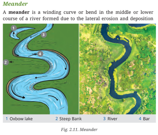
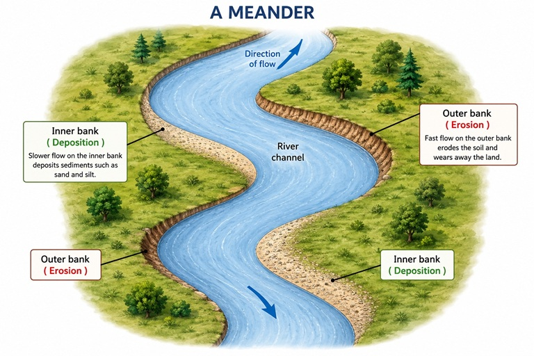
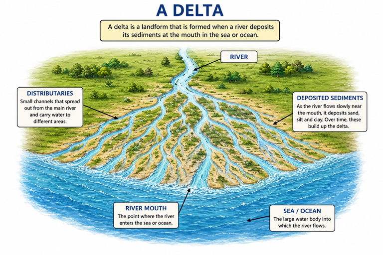
Q5. Draw and label a diagram of a meander and a delta.
Answer:
This is a drawing activity. For the meander diagram, draw a winding S-shaped river bend and label: the outer bank (steep, eroded), the inner bank (gentle, deposited sediment/bar), and an oxbow lake (a cut-off loop). For the delta diagram, draw a fan/triangular shape at a river mouth entering the sea, and label: the main river channel, distributaries (smaller branching channels), deposited islands/bars, and the sea. Refer to the textbook figures (Fig. 2.11 for meander, Fig. 2.12 for delta) as a reference for accurate labelling.
Page 2-3 - Plate Tectonics (Earth's Interior)
Q1. Explain the structure of the Earth's interior with reference to its three main layers.
Answer:
The Earth is made up of three main layers:
- Crust (Outermost Layer):
- The thinnest layer on which we live
- Composed of solid rocks and soil
- Thickness: 5-70 km (thinner under oceans, thicker under continents)
- Mantle (Middle Layer):
- Found below the crust
- Very thick and hot
- Upper part is solid, lower part is semi-molten
- Convection currents in the mantle drive plate movement
- Core (Innermost Layer):
- Extremely hot and heavy
- Made of iron and nickel
- Outer core is liquid, inner core is solid
- Generates the Earth's magnetic field
Additional Terms:
- Lithosphere: The crust along with the upper part of the mantle
- Asthenosphere: Semi-molten layer beneath the lithosphere that allows plates to move
Q2. What is the lithosphere and how is it different from the asthenosphere?
Answer:
Lithosphere:
- The crust along with the upper part of the mantle
- It is solid and rigid
- Broken into tectonic plates that move over the asthenosphere
- Thickness: about 100 km
Asthenosphere:
- Lies beneath the lithosphere
- It is semi-molten (partially melted)
- Allows the movement of tectonic plates through convection currents
- Extends from about 100-250 km below the surface
Page 3-4 - LET'S MAP (Tectonic Plates)
Q1. 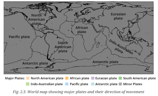 Pick any two plates from the map above and complete the table given below.
Answer:
Tectonic Plates: Sample comparision
| Name of the Plate | Continents | Ocean |
|---|---|---|
| Eurasian Plate | Europe and Asia | Part of the Atlantic and Arctic Oceans |
| Pacific Plate | None (mostly oceanic) | Pacific Ocean |
* alternative pair *
Alternative pair two plates
| Name of the Plate | Continents | Ocean |
|---|---|---|
| North American Plate | North America | Atlantic and Pacific Oceans |
| African Plate | Africa | Atlantic and Indian Oceans |
Note: plates include both continental and oceanic lithospheresample data · tectonic geography
Q2. What are the three main types of plate boundaries? Explain each with examples.
Answer:
The three main types of plate boundaries are:
- Convergent Boundary (Colliding Plates):
- Two plates move towards each other
- Continental-Continental: Form fold mountains (e.g., Himalayas)
- Oceanic-Continental: Oceanic plate sinks (subduction) causing volcanoes and earthquakes
- Oceanic-Oceanic: Forms island arcs (e.g., Japan, Philippines)
- Divergent Boundary (Separating Plates):
- Two plates move away from each other
- Magma rises from below and forms new crust
- Creates mid-ocean ridges (e.g., Mid-Atlantic Ridge)
- On land: Forms rift valleys (e.g., East African Rift Valley)
- Transform Boundary (Sliding Plates):
- Two plates slide past each other
- No creation or destruction of crust
- Mainly causes earthquakes (e.g., San Andreas Fault, California)
Page 4-5 - LET'S EXPLORE (Ring of Fire)
Q1. Examine the plate map (Fig. 2.3) with the earthquake and volcano map (Fig. 2.4). What correlation do you observe?
Answer:
Correlation between Plate Map and Earthquake/Volcano Map:
- Earthquakes and volcanoes are concentrated along plate boundaries — not randomly distributed
- Convergent boundaries (where plates collide) show the highest concentration of earthquakes and volcanoes
- The Pacific Plate boundary is the most active — known as the Ring of Fire
- Divergent boundaries (mid-ocean ridges) also show volcanic activity but fewer earthquakes
- Transform boundaries show frequent earthquakes but fewer volcanoes
- Areas in the interior of plates (away from boundaries) show little or no seismic activity
Q2. 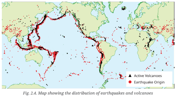 Observe the map showing the distribution of earthquakes and volcanoes (Fig. 2.4). Can you identify which continents and countries are located around the Ring of Fire with the help of an atlas or a globe?
Answer:
The Ring of Fire — Countries and Continents:
The Ring of Fire is a region around the Pacific Ocean where most earthquakes and volcanoes occur. It includes:
Continents:
- Asia (eastern and southeastern parts)
- North America (western part)
- South America (western part)
- Australia (eastern part)
Countries:
- Japan — frequent earthquakes and volcanoes
- Indonesia — many active volcanoes
- Philippines — along the Pacific Ring of Fire
- New Zealand — active seismic zone
- Chile — frequent earthquakes
- United States (Alaska and California) — San Andreas Fault
- Mexico — volcanic activity
- Russia (Kamchatka Peninsula) — active volcanoes
Page 5-6 - LET'S EXPLORE (Earthquake Risk in India)
Q1. Does India have a risk of earthquakes? India has experienced some major earthquakes in the past, resulting in thousands of deaths. A large earthquake in a densely populated country like India can cause severe damage to life and environment. Can you find out which region is more vulnerable to earthquakes? Why do you think human lives are at risk?
Answer:
Yes, India has a significant risk of earthquakes.
Earthquake-Vulnerable Regions in India:
- Zone V (Very High Risk): Himalayan region including Kashmir, Himachal Pradesh, Uttarakhand, Sikkim, and parts of Northeast India
- Zone IV (High Risk): Delhi, parts of Punjab, Uttar Pradesh, Bihar, West Bengal, and Gujarat
- Zone III (Moderate Risk): Parts of Maharashtra, Madhya Pradesh, and Tamil Nadu
Why human lives are at risk:
- High Population Density: Many earthquake-prone areas are densely populated
- Poorly Constructed Buildings: Many buildings are not earthquake-resistant
- Lack of Awareness: People are often unprepared for earthquakes
- Impossible to Predict: Earthquakes cannot be predicted, making early warning difficult
- Secondary Disasters: Earthquakes trigger landslides, tsunamis, and building collapses
Major Earthquakes in India:
- Bhuj Earthquake, Gujarat (2001): Magnitude 7.7, thousands died
- Kashmir Earthquake (2005): Magnitude 7.6, severe damage
- Uttarkashi Earthquake (1991): Magnitude 6.8
- Latur Earthquake, Maharashtra (1993): Magnitude 6.4
Page 6 - DON'T MISS OUT (Ancient Earthquake Knowledge)
Q1. In early times too, earthquakes were known as 'bhukampa', meaning the shaking of the Earth. In the Brihatsamhita, Varahamihira dedicated a section to earthquakes, noting how changes in wind, rain, clouds, animal behaviour, and planetary alignments could signal them. He attributed earthquakes to four elemental forces — Vayu (wind), Agni (fire), Indra (heaven/thunder), and Varuna (water), each linked to specific constellations and regions. This reflects an early attempt to blend observations with cosmological reasoning and physical phenomenon in India. What does this tell us about ancient Indian knowledge?
Answer:
What this reveals about ancient Indian knowledge:
- Scientific Observation: Ancient Indians observed natural phenomena and tried to understand them
- Interdisciplinary Approach: They connected astronomy, meteorology, and geology
- Early Seismology: They attempted to understand earthquakes and their causes
- Practical Application: They tried to predict earthquakes based on observations
- Comprehensive Understanding: They considered multiple factors — wind, rain, clouds, animal behaviour
- Cosmological Connection: Linked physical phenomena with cosmic and elemental forces
- Continuity: Shows the rich tradition of scientific inquiry in ancient India
Page 6-7 - LET'S EXPLORE (Volcanic Eruption)
Q1. Look carefully at this photograph and answer the following questions: What do you think caused this situation? What could that grey powder be? What does it tell us about the Earth's internal forces?
Answer:
What caused this situation:
- A volcanic eruption caused this situation where grey ash and dust cover everything
What the grey powder could be:
- The grey powder is volcanic ash — fine particles of pulverised rock, glass, and mineral fragments
- It is ejected from the volcano during an eruption
- Volcanic ash can spread over large areas, covering buildings, roads, and farmland
What this tells us about the Earth's internal forces:
- Earth's Interior is Active: The Earth's interior is extremely hot and under high pressure
- Magma Movement: Magma from the mantle rises through cracks in the crust
- Plate Tectonics: This happens at plate boundaries where plates converge or diverge
- Release of Energy: Volcanic eruptions are a release of the Earth's internal energy
- Powerful Forces: The Earth's internal forces are immensely powerful and can reshape the surface
Page 7 - Mud Volcano (Baratang Island)
Q1. What is special about the mud volcano at Baratang Island in the Andaman and Nicobar Islands?
Answer:
Baratang Island Mud Volcano — Key Facts:
- Rare Natural Wonder: It is a rare mud volcano in India
- Unique Attraction: A unique attraction of the Andaman and Nicobar Islands
- Not Fiery: Unlike fiery volcanoes, it has mud bubbling out
- Cause: Due to natural underground gases and pressure
- Formation: Gases trapped underground push mud, water, and rocks to the surface
- Mud Volcanoes: Are found in volcanic and tectonic regions where gases escape
Page 7-8 - Weathering (Types and Processes)
Q1. What is weathering? Explain the three main types of weathering with examples.
Answer:
Weathering is the process through which rocks on the Earth's surface break down into smaller pieces due to various processes. It does not involve movement, only breakdown.
The three main types of weathering are:
- Physical Weathering:
- Rocks break into smaller pieces due to physical forces
- Causes: Temperature changes, frost, wind, and water
- Examples: Freeze-thaw (water freezes in cracks, expands, breaks rocks); Exfoliation (outer layers peel off due to temperature changes)
- Chemical Weathering:
- Minerals in rocks change chemically
- Causes: Reaction with water, air, or acids
- Examples: Oxidation (rusting of iron-bearing rocks); Carbonation (limestone dissolves in acidic water); Hydrolysis (minerals react with water)
- Biological Weathering:
- Breaking down of rocks by living organisms
- Causes: Plants, animals, and micro-organisms
- Examples: Plant roots growing into cracks and splitting rocks; Burrowing animals (earthworms, rodents) breaking rocks; Lichen and moss releasing chemicals that dissolve rocks
Page 8-9 - Erosion and its Impact
Q1. What is erosion? How is it different from weathering? Explain the types of erosion.
Answer:
Erosion is the process by which soil, rocks, and other surface materials are worn away and carried from one place to another by natural agents like water, wind, ice, or waves.
Types of Erosion:
- Water Erosion:
- Caused by rivers, rain, or ocean waves
- Forms valleys, canyons, deltas
- Wind Erosion:
- Common in dry and sandy areas
- Forms sand dunes, yardangs
- Glacial Erosion:
- Where moving ice scrapes and carries rocks
- Forms U-shaped valleys, fjords
- Coastal Erosion:
- Where sea waves wear away the land
- Forms cliffs, sea arches, stacks
Weathering vs Erosion Key differences
· breakdown & movement
- Weathering — in-situ breakdown
- Erosion — breakdown + transport
- ? geography · earth science
| Weathering | Erosion |
|---|---|
| Only breaks down rocks | Breaks down AND moves materials |
| No movement involved | Involves transportation |
| Material stays in place | Material is carried away |
Page 9 - LET'S EXPLORE (Erosion and Farmers)
Q1. Observe the photographs (Fig. 2.9) and also note the types of erosion. How are farmers affected by erosion due to water and wind?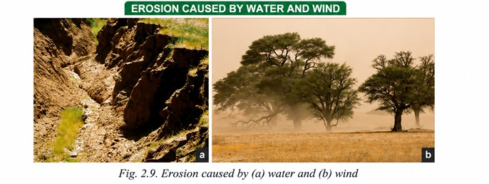
Answer:
Effects of Erosion on Farmers:
Water Erosion:
- Removes the fertile topsoil needed for crops
- Leads to lower crop yields and reduced agricultural productivity
- Can create gullies and rills on farmlands
- Causes sedimentation in rivers and reservoirs
- Example: Soil erosion in the Ganga plains after heavy rains
Wind Erosion:
- Blows away nutrient-rich soil particles
- Dries out the soil, reducing soil moisture
- Can cause sandstorms that damage crops
- Common in desert and semi-arid regions
- Example: Desertification in Rajasthan
Overall Impact:
- Reduced farm income and livelihoods
- Food security concerns
- Need for soil conservation measures (terracing, bunding, afforestation)
Page 9 - DON'T MISS OUT (Water Management in Ancient India)
Q1. The Sindhu-Sarasvati civilisation employed sophisticated techniques, including contouring, bunding, terracing, dams, and canals for water management. Multiple Sanskrit texts document these practices, including the Vedas, Krishtiparashara, Kautilya's Arthashastra, and specialised treatises like Vrikshayurveda. The Arthashastra contains detailed guidelines on land assessment and categorisation based on fertility and productivity. The Zabo system in Nagaland represents an integrated farming approach using earthen bunds on hillslopes for soil and water conservation. What do these ancient practices tell us?
Answer:
What these ancient practices reveal:
- Advanced Knowledge: Ancient Indians had sophisticated knowledge of water management and soil conservation
- Sustainable Practices: They used sustainable techniques that are still relevant today
- Documented Knowledge: Practices were recorded in texts like the Vedas, Arthashastra, and Vrikshayurveda
- Land Assessment: The Arthashastra had detailed guidelines on land categorisation based on fertility
- Regional Practices: The Zabo system in Nagaland shows regional variations in soil conservation
- Continuity: Many of these practices are still used today by farmers
- Holistic Approach: They integrated agriculture, water management, and soil conservation
Page 10-12 - Running Water Landforms (Waterfall, Meander, Delta)
Q1. Describe the landforms created by running water in the upper, middle, and lower courses of a river.
Answer:
Running water creates various landforms along a river's course:
Upper Course (Near the Source):
- V-shaped Valleys: Formed by vertical erosion as the river cuts downward
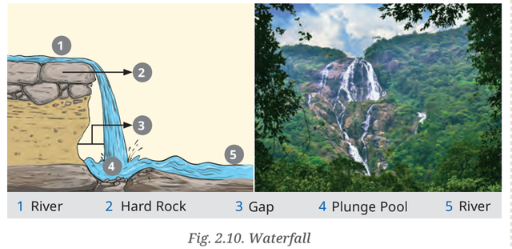
- Waterfalls: Where the river flows over a steep cliff or vertical drop
- Rapids: Fast-flowing water over hard rocks
- Gorges and Canyons: Deep, narrow valleys
Middle Course:
- Meanders: Winding curves or bends formed by lateral erosion and deposition
- Oxbow Lakes: When meanders are cut off from the main river
- Floodplains: Flat areas along the river where sediments are deposited during floods
Lower Course (Near the Mouth):
- Deltas: Fan-shaped or triangular deposits at the river mouth
- Levees: Raised banks along the river formed by sediment deposition
- Alluvial Fans: Cone-shaped deposits where the river spreads out
- Estuaries: Where the river meets the sea
Q2. What is a waterfall and how is it formed? Why are waterfalls important to humans?
Answer:
Waterfall: A landform where a river flows over a steep cliff or vertical drop, creating a dramatic fall.
Formation of Waterfalls:
- Form in the upper course of rivers
- Hard rocks resist erosion while softer rocks below are worn away
- The soft rock erodes faster, creating a sudden drop
- The river falls over the hard rock ledge
Importance of Waterfalls to Humans:
- Tourism: Beautiful natural features attract tourists (e.g., Niagara Falls, Jog Falls)
- Hydroelectric Power: Used for generating electricity from falling water
- Recreation: Provide opportunities for trekking, photography, and adventure sports
- Cultural Significance: Often have religious or cultural importance in certain regions
- Local Economy: Tourism generates income for local communities
Q3. What is a meander? How is it formed and why is it important for human activities?
Answer:
Meander: A winding curve or bend in the middle or lower course of a river, formed due to lateral erosion and deposition of sediments.
Formation of Meanders:
- The river erodes the outer banks of bends (where water flows faster)
- Sediment is deposited on the inner banks (where water flows slower)
- Over time, this creates large loops
- Meanders can be cut off to form oxbow lakes
Importance of Meanders for Humans:
- Agriculture: Fertile soil deposited along meanders supports farming
- Settlement Patterns: Villages and towns often develop on gentle slopes near meanders
- Navigation: Meandering rivers can be used for transport
- Irrigation: Water from meandering rivers is used for irrigation
- Tourism: Scenic curves create attractive landscapes
- Example: The Grand Anicut (Kallanai) in Tamil Nadu uses river water for irrigation
Q4. What is a delta? Why are deltas important for human settlements and agriculture?
Answer:
Delta: A landform formed at the mouth of a river where it flows into a sea, ocean, or lake, depositing sediments from upstream.
Formation of Deltas:
- The river slows down near the mouth
- Sediments carried by the river are deposited
- Over time, deposits accumulate to form a fan-shaped or triangular area
- Example: Sundarbans delta (formed by the Ganga and Brahmaputra rivers)
Why Deltas are Important:
- Fertile Soil: Rich alluvial soil makes deltas ideal for agriculture
- Food Production: Support crops like rice and jute
- Fishing: Mix of fresh and saltwater creates diverse aquatic life
- Dense Settlements: Support large human populations
- Trade and Transport: Rivers provide navigable routes
- Biodiversity: Support rich ecosystems (e.g., Sundarbans mangroves)
Page 13 - LET'S EXPLORE (Sundarbans Delta)
Q1. Have you heard about the Sundarbans delta? Try and explore its uniqueness and find out why it is popular with tourists.
Answer:
Sundarbans Delta — Uniqueness and Tourist Attraction:
Location: Formed by the Ganga, Brahmaputra, and Meghna rivers in India (West Bengal) and Bangladesh
Uniqueness:
- Largest Mangrove Forest: The largest contiguous mangrove forest in the world
- Royal Bengal Tiger: Home to the famous Royal Bengal Tiger
- Rich Biodiversity: Supports diverse flora and fauna — saltwater crocodiles, dolphins, spotted deer
- Riverine Ecosystem: A network of rivers, creeks, and islands
- UNESCO World Heritage Site: Designated for its natural significance
Why it is Popular with Tourists:
- Wildlife Safaris: Boat safaris to see tigers, crocodiles, and birds
- Mangrove Boat Rides: Experience the unique ecosystem up close
- Bird Watching: Home to numerous migratory and resident birds
- Scenic Beauty: Beautiful riverine landscapes and sunset views
- Cultural Experience: Visit fishing villages and learn about local life
Page 13-14 - Waves and Currents (Coastal Landforms)
Q1. What landforms are created by waves and currents along the coast?
Answer:
Landforms created by waves and currents:
Depositional Coastal Landforms:
- Beaches: Made of sand, pebbles, or rocks along the shoreline
- Sand Bars: Ridges of sand deposited by waves
- Spits: Sandbars attached to the land at one end
- Barrier Islands: Offshore islands parallel to the coast
Erosional Coastal Landforms:
- Sea Cliffs: Steep rock faces formed as waves undercut the coast
- Wave-Cut Platforms: Flat areas left behind as cliffs retreat
- Sea Caves: Hollow spaces formed when waves erode weak parts of the rock
- Sea Arches: Created when caves on opposite sides of a headland meet
- Sea Stacks: Isolated pillars of rock left standing after arches collapse
Importance to Humans:
- Beaches are popular tourist destinations
- Coastal landforms support fishing and trade
- Act as natural barriers against waves and erosion
- Provide habitats for marine life
Page 15-16 - Glacial Landforms
Q1. What landforms are created by glacial erosion and deposition?
Answer:
Glacial Erosional Landforms:
- U-shaped Valleys: Formed as glaciers widen and deepen river valleys
- Cirques: Bowl-shaped depressions at the head of a glacier
- Arete: Sharp ridges between valleys
- Hanging Valleys: Where smaller glaciers meet larger ones
- Fjords: Deep, narrow inlets created when the sea floods glacial valleys
Glacial Depositional Landforms (Moraines):
- Lateral Moraines: Form along the sides of glaciers
- Terminal Moraines: Found at the end of glaciers, marking their furthest advance
- Medial Moraines: Formed when two glaciers meet
- Ground Moraines: Deposits left beneath the glacier when it melts
Importance of Glacial Landforms to Humans:
- Tourism: U-shaped valleys and cirques attract trekkers and mountaineers
- Fjords: Used for harbours and fishing
- Agriculture: Glacial soil is fertile for farming
- Water Source: Glaciers are crucial sources of fresh water
- Hydroelectric Power: Glacial meltwater feeds rivers used for hydroelectricity
- Glacial Lake Outburst Flood (GLOF): A section of the Nanda Devi glacier broke off
- This caused a massive release of water, ice, and debris downstream
- The flood rushed down the Rishiganga and Dhauliganga rivers
- Climate Change: Rising temperatures caused glacier melting
- Glacial Instability: The glacier was already unstable and prone to breakage
- Heavy Snowfall: Recent heavy snowfall added to the glacier mass
- Steep Terrain: The steep slopes of the Himalayas accelerated the flow
- Human Activities: Hydroelectric projects and construction in the area
- Loss of human lives and livestock
- Damage to buildings, roads, bridges, and hydel projects
- Adverse effect on village connectivity
- Environmental and ecological damage
- Yardangs: Streamlined rock ridges carved by wind
- Ventifacts: Rocks polished and shaped by sandblasting
- Deflation Hollows (Blowouts): Shallow depressions where loose material is removed
- Desert Pavements: Flat surfaces left behind after finer particles are blown away
- Barchan Dunes: Crescent-shaped dunes with limited sand and a single wind direction
- Longitudinal Dunes: Long ridges formed parallel to the prevailing wind
- Star Dunes: Dunes with multiple arms formed where winds come from different directions
- Parabolic Dunes: U-shaped dunes often stabilised by vegetation
- Dunes act as natural barriers against desertification
- Provide areas for tourism and adventure sports
- Protect coastal settlements from wind and waves
- Sand is sometimes used for construction
- Created by underground water especially in areas of limestone or soluble rocks
- Through chemical weathering and erosion
- Water dissolves the rock, creating unique landforms
- Caves: Hollow spaces formed as acidic water dissolves rock
- Stalactites: Icicle-shaped formations hanging from the ceiling of caves
- Stalagmites: Formations rising from the floor of caves
- Columns: Formed when stalactites and stalagmites join
- Sinkholes (Dolines): Depressions formed when the ground collapses into an underground cavity
- Underground Rivers: Rivers that flow through cave systems
- Water Source: Caves provide fresh water
- Tourism: Caves attract tourists and adventurers
- Cultural/Religious Significance: Many caves have religious importance
- Scientific Study: Attract geologists and researchers
- Recreation: Caving and exploring are adventure activities
- Hills/Mountains: Formed by internal forces (plate tectonics, folding, faulting)
- River Valleys: Formed by running water (erosion and deposition)
- Plains: Formed by deposition of sediments by rivers
- Coastal Features: Formed by waves and currents
- Sand Dunes: Formed by wind
- Caves: Formed by underground water
- Soil Formation: Caused by weathering of rocks
- Mountainous regions with heavy snowfall
- Himalayan region — Himachal Pradesh, Uttarakhand, Jammu & Kashmir
- Alps, Rockies, Andes in other parts of the world
- Heavy snowfall adding extra weight to snowpack
- Sudden temperature rise causing partial melting
- Strong winds piling up snow unevenly
- Natural disturbances (earthquakes, vibrations)
- Human activities (skiing, trekking, construction)
- Avalanche forecasting and early warning systems
- Snow barriers and deflectors
- Controlled avalanches using explosives
- Avoid construction in avalanche-prone areas
- Public awareness and evacuation plans
- Siachen Glacier (2023) — Multiple avalanches affected Army personnel
- Kashmir (2022) — Avalanches in Gulmarg and Sonmarg
- Nepal (2021) — Avalanche in the Himalayas during trekking season
- Desert and semi-arid regions
- Rajasthan, Gujarat, parts of Punjab in India
- Middle East, Sahara Desert, Central Asia globally
- Prolonged drought and low rainfall drying out soil
- Sparse vegetation due to deforestation and overgrazing
- Climate change and extreme weather conditions
- Loose, dry soil in desert areas
- Afforestation and vegetation cover
- Soil conservation practices (contour ploughing, mulching)
- Windbreaks (shelterbelts of trees)
- Water conservation to keep soil moist
- Early warning systems and public awareness
- Delhi-NCR (2023) — Severe dust storms in summer
- Rajasthan (2022) — Dust storms affecting visibility and health
- Middle East (2021) — Massive dust storms across UAE and Saudi Arabia
- Heat from the Earth's Core:
- The Earth's core is extremely hot (about 5,000°C)
- This heat is generated by radioactive decay of elements like uranium, thorium, and potassium
- Also from the gravitational energy released during the Earth's formation
- Convection Currents:
- Heat from the core causes molten material in the mantle to rise
- Cooler material sinks, creating convection currents
- These currents push and pull the tectonic plates
- Radioactive Decay:
- Continuous radioactive decay of elements inside the Earth releases energy
- This energy maintains the heat of the core over billions of years
- Earthquakes occur due to the sudden release of energy in the Earth's crust
- This happens when tectonic plates move past, towards, or away from each other
- Stress builds up along plate boundaries and is suddenly released
- This causes seismic waves that shake the Earth's surface
- Along plate boundaries — convergent, divergent, and transform
- Ring of Fire: Around the Pacific Ocean (Japan, Indonesia, Chile, California)
- Himalayan region — India, Nepal, Pakistan
- Mid-ocean ridges — under the ocean
- San Andreas Fault — California, USA
- No, earthquakes cannot be predicted with current scientific knowledge
- Challenges:
- Earthquakes occur suddenly without warning
- Scientists can identify earthquake-prone zones but not the exact timing
- Early warning systems can provide seconds to minutes of advance notice
- In ancient India, Varahamihira tried to predict earthquakes using observations of wind, rain, animal behaviour, and planetary alignments
- Earthquakes and volcanoes are not randomly distributed on the Earth's surface
- They are concentrated along plate boundaries
- Earthquakes: Stress builds up as plates collide and is released suddenly
- Volcanoes: When oceanic plates subduct, melting occurs, and magma rises
- Example: The Ring of Fire around the Pacific Ocean — the most active zone
- Earthquakes: Less powerful, but occur as plates move apart
- Volcanoes: Magma rises to fill the gap, forming new crust
- Example: The Mid-Atlantic Ridge
- Earthquakes: Frequent and powerful as plates grind past each other
- Volcanoes: Rare, as there is no subduction or magma rise
- Example: San Andreas Fault in California
- The Pacific Plate boundary (Ring of Fire) has the most earthquakes and volcanoes
- Areas in the interior of plates (away from boundaries) are relatively stable
- River channel
- Outer bank (erosion)
- Inner bank (deposition)
- Direction of flow
- Oxbow lake (if present)
- River mouth
- Distributaries
- Deposited sediments
- Sea/Ocean
- Fan shape
- Deforestation (removal of trees) leads to increased erosion
- Loss of Root Systems:
- Tree roots hold the soil together
- Without roots, soil becomes loose and unstable
- Rainwater easily washes away the topsoil
- Increased Runoff:
- Trees intercept rainfall and slow down water flow
- Without trees, water flows faster, increasing surface runoff
- This leads to soil erosion
- Loss of Soil Fertility:
- Erosion removes the fertile topsoil
- This reduces agricultural productivity
- Leads to desertification in extreme cases
- Increased Sedimentation:
- Eroded soil enters rivers and dams
- This causes sedimentation and reduces water holding capacity
- Example: Deforestation in the Himalayas causing siltation in rivers
- Afforestation and reforestation
- Terracing on slopes
- Contour ploughing
- Bunding to slow water flow
- Sustainable farming practices
- Identify areas with visible soil erosion
- Check for gullies, rills, and barren patches
- Note the slope, vegetation cover, and water drainage patterns
- Plant Trees: Plant native trees and shrubs with deep roots
- Terracing: Create steps on slopes to slow water flow
- Contour Ploughing: Plough across the slope, not down it
- Bunding: Build earthen embankments along contour lines
- Mulching: Cover soil with organic matter to protect from wind and rain
- Rainwater Harvesting: Collect and store rainwater
- Check Dams: Build small structures to slow water flow
- Drainage Channels: Create proper drainage systems to prevent waterlogging
- Organise community awareness programmes
- Involve schools and local organisations
- Plant trees during monsoon season
- Regularly inspect the area for signs of erosion
- Maintain terrace walls and bunds
- Replace dead plants and ensure growth
- Depending on the region, common disasters include earthquakes, floods, landslides, droughts, and cyclones
- Preparedness:
- Create emergency kits with food, water, medicines, and first aid
- Prepare evacuation plans and identify safe zones
- Practice emergency drills (fire drills, earthquake drills)
- Stay informed about weather warnings and alerts
- During a Disaster:
- Stay calm and follow emergency procedures
- Move to safe locations away from danger
- Listen to official instructions from authorities
- Avoid rumours and misinformation
- After a Disaster:
- Check for injuries and provide first aid
- Contact emergency services for help
- Follow public health guidelines to prevent diseases
- Participate in relief and recovery efforts
- Spread awareness about disaster preparedness
- Participate in community drills
- Create posters and educational materials
- Help with relief work when safe to do so
- Thermocol/plaster of Paris for the base
- Clay or play-dough
- Paint and brushes
- Small stones and pebbles
- Labels and markers
- Cave: A hollow underground space formed by chemical weathering
- Stalactites: Icicle-shaped formations hanging from the cave ceiling
- Stalagmites: Formations rising from the cave floor
- Columns: Where stalactites and stalagmites meet
- Sinkhole: A depression on the surface where the ground collapsed
- Underground River: A river flowing through the cave system
- Create a cross-section model showing the surface and underground
- Build the cave structure using clay or thermocol
- Add stalactites and stalagmites using clay
- Paint to show rock layers and water
- Add labels to identify each landform
- Include a key/legend explaining the features
- Structural Safety:
- Ensure buildings are earthquake-resistant
- Avoid construction in floodplains and landslide-prone areas
- Retrofit older buildings to meet safety standards
- Emergency Kit:
- Prepare an emergency kit with food, water, medicines, torch, and batteries
- Keep important documents in a safe place
- Family Plan:
- Create a family communication plan
- Identify safe spots in each room
- Practice drop, cover, and hold on drill
- Indoors:
- Drop, Cover, and Hold On under a sturdy table
- Stay away from windows, glass, and heavy objects
- Do not use elevators
- Outdoors:
- Move to an open area away from buildings and power lines
- Stay away from trees, signs, and structures
- In a Vehicle:
- Pull over safely and stay inside the vehicle
- Avoid bridges, overpasses, and tunnels
- Check for injuries and provide first aid
- Listen to official announcements and updates
- Be prepared for aftershocks
- Check for gas leaks, fires, and structural damage
- Avoid damaged areas and follow evacuation orders
- Earthquakes: Locations and magnitudes
- Volcanic Eruptions: Active volcanoes and eruption dates
- Landslides: Areas affected by landslides
- Floods: Regions with flooding
- Dust Storms: Areas affected by dust storms
- Avalanches: Mountain regions with avalanche activity
- Use a blank world map or India map
- Research recent disasters from newspapers and online sources
- Use different symbols/colours for different disasters
- Add a legend to explain the symbols
- Include dates and brief details of each event
- Newspapers (The Hindu, Times of India, Indian Express)
- Government websites (NDMA, IMD)
- Online sources (WHO, ReliefWeb, USGS)
- News channels
- Mountains: Many mountains are considered sacred (e.g., Himalayas)
- Rivers: Ganga, Yamuna, Narmada, etc.
- Caves: Amarnath, Vaishno Devi, etc.
- Lakes: Pushkar, Dal Lake, etc.
- Forests: Sacred groves in many regions
- Ask elders and teachers for local stories
- Read mythological and historical texts
- Explore regional traditions and customs
- Include images/drawings of the landforms
- Write the folk stories in brief
- Explain the cultural significance
- Add colourful visuals and attractive layout
- Loss of Life: More than 200 people lost their lives
- Infrastructure Damage:
- Two hydroelectric projects (Tapovan and Rishiganga) were destroyed
- Many bridges, roads, and buildings were damaged
- Livelihoods:
- Farmers lost agricultural land and crops
- Local businesses and tourism were severely affected
- Connectivity:
- Many villages were cut off from the rest of the state
- Roads and bridges were washed away
- Environmental Impact:
- River ecosystems were damaged
- Sedimentation affected water quality
- Early warning systems for glacial lake outbursts
- Monitoring of glaciers using satellite technology
- Evacuation plans for vulnerable areas
- Awareness programmes for local communities
- Grow more trees that can hold the soil together
- Listen to Radio/Watch TV and Newspaper for any alerts
- Keep drains clean, keep holes open
- Watch out for warning signs — subsidence of building, cracks on rocks, muddy river water
- DO NOT construct near steep slopes and near drainage path
- Stay calm, DO NOT panic, ignore rumours
- Stay together — with your companions
- If you notice warning signs — unusual sounds like trees cracking or boulders knocking together
- Move away from landslide path or downstream valley quickly
- Inform nearest Tehsil/District HQ
- Move away from landslide path or downstream valley quickly
- Inform nearest Tehsil/District HQ
- Be Smart, Be Prepared
- Translate the above content into your native language
- Use clear and simple language for easy understanding
- Display the poster in a visible location at home
- Share with neighbours and family members
- Rivers, rain, and ocean waves
- Flooding and water runoff
- Deforestation and poor land management
- Loss of fertile topsoil, reducing agricultural productivity
- Damage to houses, roads, and infrastructure
- Flooding causing loss of life and property
- Sedimentation in rivers and dams
- Terracing and contour ploughing
- Afforestation and reforestation
- Building check dams and embankments
- Flood warning systems and evacuation plans
- Drought and low rainfall
- Deforestation and overgrazing
- Loose, dry soil in desert areas
- Loss of fertile topsoil, reducing agricultural productivity
- Dust storms affecting health and visibility
- Desertification and land degradation
- Damage to crops and property
- Windbreaks and shelterbelts
- Afforestation and vegetation cover
- Soil conservation practices (mulching, bunding)
- Water conservation and moisture retention
- Moving ice scraping and carrying rocks
- Glacial melting due to climate change
- Glacial lake outburst floods
- Loss of life and property from glacial floods
- Damage to infrastructure (roads, bridges, hydroelectric projects)
- Loss of fresh water sources as glaciers melt
- Changes in river flow patterns
- Monitoring of glacial lakes using satellite technology
- Early warning systems for glacial outbursts
- Evacuation plans for vulnerable areas
- Climate change mitigation and adaptation
Page 17 - THINK ABOUT IT (Chamoli Flood 2021)
Q1. A devastating flood struck the Chamoli district in Uttarakhand in February 2021 in which many people and livestock lost their lives. There was severe damage to buildings, roads, bridges, and hydel projects, and connectivity to villages was adversely affected. Can you find out the reasons that led to the sudden and unexpected flood?
Answer:
Chamoli Flood 2021 — Causes:
Primary Cause:
Contributing Factors:
Impact:
Page 17-18 - Wind Erosion Landforms
Q1. What landforms are created by wind erosion and deposition?
Answer:
Wind Erosional Landforms:
Wind Depositional Landforms:
Importance to Humans:
Page 19-20 - Underground Water (Karst Topography)
Q1. What is Karst topography? What landforms are created by underground water?
Answer:
Karst Topography:
Landforms Created by Underground Water:
Importance to Humans:
Page 20 - LET'S EXPLORE (Landforms Around School)
Q1. Observe the landforms around your school or residence and try to identify which agent may have created them.
Answer:
Activity Guide — Observing Local Landforms:
What to observe:
Sample Observations:
| Landform Observed | Possible Agent | Reason |
|---|---|---|
| Small hill near my school | Internal forces (folding) | Raised land surface with slopes |
| River in my town | Running water | Flowing water has carved the valley |
| Flat agricultural fields | Deposition (river) | Fertile alluvial soil |
| Sand dunes in nearby area | Wind | Desert/semi-arid region |
Page 20-21 - Landforms and Disasters (Avalanches, Dust Storms)
Q1. Avalanches — Prone areas, Mitigation measures, Recent examples
Answer:
Avalanches:
Definition: Sudden instability of snow on steep mountain slopes causing a mass of snow to slide down.
Prone Areas:
Causes:
Mitigation Measures:
Recent Examples:
Q2. Dust Storms — Prone areas, Mitigation measures, Recent examples
Answer:
Dust Storms:
Definition: Strong winds lifting large amounts of loose, dry soil and sand into the air.
Prone Areas:
Causes:
Mitigation Measures:
Recent Examples:
Pages 25-26 - Questions and Activities
Q1. What are the sources of energy that are required to cause movements associated with the internal forces of the Earth?
Answer:
Sources of energy for internal forces of the Earth:
Q2. Relate various physiographic divisions you have studied in the earlier grades with various endogenic forces responsible for their origin.
Answer:
→ Physiographic Divisions · Endogenic Forces
India's landforms · forces that shaped them · examples
| Physiographic Division | Endogenic Force Responsible | Example |
|---|---|---|
| Himalayan Mountains | Convergent plate movement (Continental-Continental collision) | Indo-Australian plate colliding with Eurasian plate |
| Northern Plains | Depositional (not endogenic) — formed by rivers | Ganga, Indus, Brahmaputra rivers |
| Peninsular Plateau | Faulting and volcanic activity | Deccan Plateau formed by volcanic eruptions |
| Western Ghats | Faulting and erosion | Formed by block faulting along the western coast |
| Eastern Ghats | Folding and faulting | Older mountains worn down by erosion |
| Coastal Plains | Depositional (not endogenic) | Formed by rivers and sea waves |
| Islands (Andaman & Nicobar) | Volcanic activity and plate movement | Volcanic islands in the Bay of Bengal |
Q3. Why and where do earthquakes occur frequently? Is it possible to predict earthquakes?
Answer:
Why Earthquakes Occur:
Where Earthquakes Occur Frequently:
Is it possible to predict earthquakes?
Q4. "Plate movements are responsible for the distribution of earthquakes and volcanoes." Explain.
Answer:
Plate movements are responsible for the distribution of earthquakes and volcanoes:
At Convergent Boundaries (Colliding Plates):
At Divergent Boundaries (Separating Plates):
At Transform Boundaries (Sliding Plates):
Summary:
Q5. Draw and label a diagram of a meander and a delta.
Answer:
Diagram of a Meander:
Key Labels for Meander Diagram:
Diagram of a Delta:
Key Labels for Delta Diagram:
Q6. How are deforestation and erosion associated with each other? Explain.
Answer:
Deforestation and Erosion are closely connected:
How Deforestation Causes Erosion:
Mitigation Measures:
Q7. Develop a plan to protect the land in your local area from erosion.
Answer:
Land Protection Plan Against Erosion:
Step 1: Assessment of the Area
Step 2: Preventive Measures
Step 3: Water Management
Step 4: Community Participation
Step 5: Monitoring and Maintenance
Q8. Which disasters do you think you might experience in your region? Discuss a mitigation plan in your classroom.
Answer:
Sample Mitigation Plan — Classroom Discussion:
Identify Disasters:
Mitigation Plan Template:
Role of Students:
Q9. Prepare a model of landforms created by underground water.
Answer:
Model of Underground Water Landforms (Karst Topography):
Materials Needed:
Landforms to Include in the Model:
Step-by-Step Instructions:
Q10. What precautionary measures will you take if you are staying in an earthquake-prone region?
Answer:
Precautionary Measures in Earthquake-Prone Regions:
Before an Earthquake:
During an Earthquake:
After an Earthquake:
Q11. Prepare a map showing landform-associated disasters that happened in the current calendar year.
Answer:
Activity Guide — Disaster Map:
What to include on the map:
Method:
Sources of Information:
Q12. Create a poster showing landforms that are considered to be sacred or important in your region, and add the folk stories associated with them.
Answer:
Poster Activity Guide — Sacred Landforms:
Step 1: Identify Sacred Landforms in Your Region
Step 2: Research Folk Stories
Step 3: Poster Design
→ Sacred Landforms · Folk Stories
India's sacred geography · myths & significance
| Landform | Region | Folk Story / Significance |
|---|---|---|
| Mount Kailash | Himalayas | Believed to be the abode of Lord Shiva and Goddess Parvati |
| River Ganga | North India | Believed to have descended from heaven to earth; water considered sacred |
| Amarnath Cave | Jammu & Kashmir | Contains a natural ice lingam, believed to be formed by Lord Shiva |
| Tirupati Hills | Andhra Pradesh | Home to the famous Venkateswara Temple |
→ Sacred landforms · cultural geography folk traditions · India
Q13. Document a case of a disaster that hit your region in the past, highlighting its effects on various human activities.
Answer:
Sample Case Study — Disaster Documentation:
Case Study: Chamoli Flood, Uttarakhand (February 2021)
Type of Disaster: Glacial Lake Outburst Flood (GLOF)
Location: Chamoli district, Uttarakhand, India
Date: 7 February 2021
Cause: A section of the Nanda Devi glacier broke off, releasing water, ice, and debris down the Rishiganga and Dhauliganga rivers.
Effects on Human Activities:
Mitigation Measures:
Q14. Translate the given poster on landslide into your native language and display it in your home.
Answer:
Landslide Preparedness Poster — Translation Activity:
Original English Content:
Title: LANDSLIDE — Ready Now to Stay Secure
Before:
During:
After:
National Disaster Management Authority Call: 011-1878
Translation Instructions:
Q15. Divide the class into three groups. Each group will work on one project (water, wind, and glacier). The project should highlight the causes, impact on human life and the environment, and mitigation measures.
Answer:
Group Project Guide — Water, Wind, and Glacier:
Group 1: Water (Running Water and Coastal Waves)
Causes of Water Erosion:
Impact on Human Life and Environment:
Mitigation Measures:
Group 2: Wind
Causes of Wind Erosion:
Impact on Human Life and Environment:
Mitigation Measures:
Group 3: Glacier
Causes of Glacial Erosion:
Impact on Human Life and Environment:
Mitigation Measures: