
BIG QUESTIONS (Page 27)
Q1. What are oceans and continents? What are their names and their distribution?
Answer:
Oceans are large water bodies that cover about three-fourths of Earth's surface.
Continents are large continuous expanses of land.
The five oceans are: Pacific Ocean, Atlantic Ocean, Indian Ocean, Southern (Antarctic) Ocean, Arctic Ocean.
Major continents are: Africa, Antarctica, Asia, Australia, Europe, North America, South America.
Oceans are not equally distributed—Southern Hemisphere has more water than Northern Hemisphere.
Q2. In what ways do oceans and continents impact life on Earth, including human life?
Answer:
Oceans and continents shape climate, provide resources, influence weather patterns, support diverse life forms, enable agriculture through monsoon rains, pose natural disasters like cyclones and tsunamis, impact history and culture (e.g., Indian Navy emblem with Varuna).
Oceans hold most water but are salty; freshwater is limited, causing water scarcity issues.
LET'S EXPLORE (Page 29)
Q1. What are the circular lines in each map called? And do you know what the lines radiating out of the two poles are called? (Hint: you studied them in the previous chapter, but here they are presented differently.)
Answer:
The circular lines are called parallels of latitude (or simply latitudes).
The lines radiating out from the poles are called meridians of longitude. These are the same lines studied in the previous chapter but shown in a different perspective—viewed from above the poles.
Q2. Which hemisphere holds more water?
Answer:
The Southern Hemisphere holds more water than the Northern Hemisphere.
This is because the Southern Hemisphere has a larger proportion of ocean area compared to land.
Q3. What do you think could be the approximate proportion of water to land in the Northern Hemisphere? And in the Southern Hemisphere? Discuss in groups.
Answer:
In the Northern Hemisphere, water covers about 61% and land about 39%. In the Southern Hemisphere, water covers about 81% and land about 19%. (These are approximate figures as per standard geographic data; students can discuss in groups.)
Q4. Are all the oceans connected with one another, or are there separations between them?
Answer:
All oceans are connected with one another. The lines dividing them on maps are only conventions; in nature, seawater constantly flows across ocean boundaries, sustaining marine life across different oceans.
THINK ABOUT IT (Page 31)
Q1. If there is such abundance of water on the planet, why is there so much talk of 'water scarcity' or a 'water crisis'?
Answer:
Although water is abundant, most of it (about 97%) is salty seawater unfit for drinking and most land animals. Freshwater makes up only a small proportion (about 3%) and is found in glaciers, rivers, lakes, atmosphere, and underground. This limited freshwater must support all human needs, and factors like pollution, overuse, unequal distribution, and climate change lead to water scarcity in many regions.
Q2. What ways of saving water are you aware of? Which ones have you seen practised at home, at your school, and in your village, town or city?
Answer:
Ways to save water include: turning off taps when not in use, fixing leaks, rainwater harvesting, using water-efficient appliances, taking shorter showers, reusing water for gardening, and collecting rainwater. At home, one might see buckets used for bathing instead of showers. At school, closing taps properly and using water from handwashing for plants. In villages, rainwater harvesting and using ponds for irrigation. In towns/cities, water recycling plants and awareness campaigns.
LET'S EXPLORE (Page 32)
Q1. As the map of oceans makes clear, the main limits of the Indian Ocean are Asia to the north, Africa to the west and Australia to the east, apart from the Southern Ocean in the south.
Answer:
This is an observation statement, not a question. Students should note the boundaries of the Indian Ocean: Asia (north), Africa (west), Australia (east), and Southern Ocean (south).
LET'S EXPLORE (Page 36)
Q1. North America and South America are generally considered to be two continents; but if seen as a single landmass, they can also be considered as one.
Answer:
This is a statement explaining different counting methods for continents. Students should understand that America can be counted as one or two continents depending on perspective.
Q2. Europe and Asia are generally considered as two continents, although the map makes it clear that they form a single landmass. For historical and cultural reasons, Europe's evolution has been very different from Asia's, which is why they can be seen as two continents. Geologists, however, often regard them as a single continent called 'Eurasia'.
Answer:
This statement explains the division between Europe and Asia. Although physically connected, historical and cultural differences keep them as separate continents traditionally; geologists often combine them as Eurasia.
Q3. Africa and Eurasia are generally regarded as two continents, but sometimes as one.
Answer:
This statement indicates that Africa and Eurasia are usually separate, but can be considered one combined landmass in some counting methods.
Q4. Write down the list of continents from the smallest to the largest.
Answer:
The list of continents from smallest to largest (in terms of area) is:
- Australia (smallest)
- Europe
- Antarctica
- South America
- North America
- Africa
- Asia (largest)
END OF CHAPTER QUESTIONS (Pages 39-40)
Q1. Explain the following terms: (a) Continent (b) Ocean (c) Island
Answer:
(a) Continent: A very large landmass on Earth's surface, surrounded by water. Examples include Asia, Africa, and Australia.
(b) Ocean: A vast body of salt water that covers most of Earth's surface.
The five major oceans are the Pacific, Atlantic, Indian, Southern, and Arctic.
(c) Island: A landmass smaller than a continent that is completely surrounded by water.
For instance, Greenland is the largest island, and India has many islands like the Andaman and Nicobar Islands.
Q2. Let us draw – Without looking at the maps in this chapter, draw the continents free hand on a sheet of paper and colour them. Then compare your drawing with the map of oceans and continents in the chapter.
Answer:
Draw a rough freehand sketch of the seven continents (Asia, Africa, North America, South America, Antarctica, Europe, Australia) on a paper. Colour each continent differently. After finishing, compare your drawing with Fig. 2.3 or any world map in the chapter to check the shapes and relative positions.
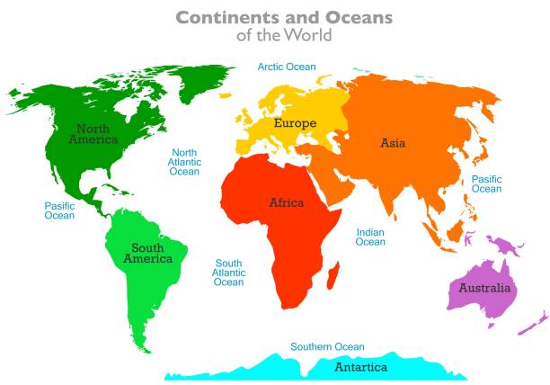
Q3. Let us do – On the outline map of the world given below, label all the continents and oceans.
Answer:
Take an outline map of the world (use the one in the book or a blank map). Label each continent: Asia, Africa, North America, South America, Antarctica, Europe, Australia. Label each ocean: Pacific Ocean, Atlantic Ocean, Indian Ocean, Southern Ocean, Arctic Ocean.
Q4. Solve this crossword Across 1. Abundantly produced by the oceans 3. A large expanse of landmass 6. A large continent of which India is a part 8. A major source of pollution of the oceans 10. The coldest continent Down 2. The largest island on Earth 4. A huge destructive wave from the ocean 5. The smallest continent 7. The largest body of water on the Earth 9. A landmass (but not a continent) surrounded by the sea or ocean
Answer:
Across: 1. OXYGEN (oceans produce oxygen)
3. CONTINENT 6. ASIA
8. PLASTIC (plastic waste is a major pollutant)
10. ANTARCTICA
Down: 2. GREENLAND 4. TSUNAMI 5. AUSTRALIA 7. PACIFIC OCEAN 9. ISLAND
Additional Note: DON'T MISS OUT Boxes (Page 37 - Greenland and Antarctica)
Q1. Why is Greenland called the largest island? How many islands does India have?
Answer:
Greenland is called the largest island because it is a huge landmass surrounded by water, but it is not large enough to be called a continent. India has more than 1,300 small islands, including the Andaman and Nicobar Islands in the Bay of Bengal and the Lakshadweep Islands in the Arabian Sea.